IMAGES TAKEN NEAR TO
Pinewood Avenue, ADDLESTONE, KT15 3AB
Introduction
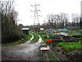
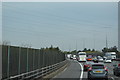
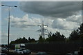
This page details the photographs taken nearby to Pinewood Avenue, KT15 3AB by members of the Geograph project.
The Geograph project started in 2005 with the aim of publishing, organising and preserving representative images for every square kilometre of Great Britain, Ireland and the Isle of Man.

There are currently over 7.5m images from over14,400 individuals and you can help contribute to the project by visiting https://www.geograph.org.uk
Image Map
Images are licensed for reuse under creativecommons.org/licenses/by-sa/2.0
Notes
- Clicking on the map will re-center to the selected point.
- The higher the marker number, the further away the image location is from the centre of the postcode.
Image Listing (64 Images Found)
Images are licensed for reuse under creativecommons.org/licenses/by-sa/2.0
Image
Details
Distance
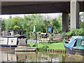
7
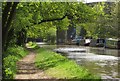
River Wey Navigation
Approaching the M5 viaduct, with smoke rising from the funnel of one of the moored craft, the MSC Frodsham (a replica Bridgewater Canal tug).
Image: © Derek Harper
Taken: 10 May 2013
0.11 miles
9
The Pig Inn
On the River Wey Navigation, almost under the M25.
Image: © Andy Stephenson
Taken: 5 May 2008
0.12 miles
10
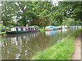
River Wey Navigation - boats moored above New Haw Lock
'Ourwey' and 'Not so fast' are the nearest.
Image: © Robin Webster
Taken: 13 Sep 2015
0.12 miles