IMAGES TAKEN NEAR TO
Green Lane, ADDLESTONE, KT15 2TU
Introduction
This page details the photographs taken nearby to Green Lane, KT15 2TU by members of the Geograph project.
The Geograph project started in 2005 with the aim of publishing, organising and preserving representative images for every square kilometre of Great Britain, Ireland and the Isle of Man.

There are currently over 7.5m images from over14,400 individuals and you can help contribute to the project by visiting https://www.geograph.org.uk
Image Map
Images are licensed for reuse under creativecommons.org/licenses/by-sa/2.0
Notes
- Clicking on the map will re-center to the selected point.
- The higher the marker number, the further away the image location is from the centre of the postcode.
Image Listing (15 Images Found)
Images are licensed for reuse under creativecommons.org/licenses/by-sa/2.0
Image
Details
Distance
2
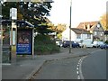
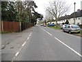
Bus stop in Chertsey Road, Addlestone
looking north
Image: © Andrew Longton
Taken: 1 Nov 2005
0.12 miles
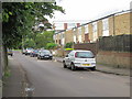
6
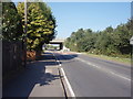
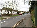
Green Lane
Pictured close to its 'T'-junction with School Lane. The bridge visible is the A317 (St. Peter's Way), just beyond it - on the right - is Abbey Moor golf course (not visible in the photograph).
Image: © Ajay Tegala
Taken: 20 Sep 2008
0.19 miles
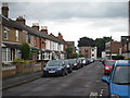
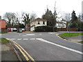
8
Green Lane from the junction with School Lane
Image: © David Howard
Taken: 11 Mar 2013
0.20 miles
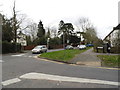
10
School Lane at the junction of Green Lane
Image: © David Howard
Taken: 11 Mar 2013
0.21 miles