IMAGES TAKEN NEAR TO
Weybridge Road, ADDLESTONE, KT15 2QT
Introduction
This page details the photographs taken nearby to Weybridge Road, KT15 2QT by members of the Geograph project.
The Geograph project started in 2005 with the aim of publishing, organising and preserving representative images for every square kilometre of Great Britain, Ireland and the Isle of Man.

There are currently over 7.5m images from over14,400 individuals and you can help contribute to the project by visiting https://www.geograph.org.uk
Image Map
Images are licensed for reuse under creativecommons.org/licenses/by-sa/2.0
Notes
- Clicking on the map will re-center to the selected point.
- The higher the marker number, the further away the image location is from the centre of the postcode.
Image Listing (7 Images Found)
Images are licensed for reuse under creativecommons.org/licenses/by-sa/2.0
Image
Details
Distance
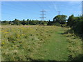
1
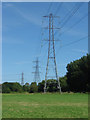
Chertsey Meads
A pylon line running from the electricity sub-station near Brooklands crossing the Meads.
Image: © Alan Hunt
Taken: 17 Aug 2012
0.11 miles
2
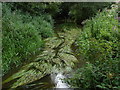
River Bourne
The Chertsey Bourne running along the border between Chertsey Meads and Woburn Park.
Image: © Alan Hunt
Taken: 16 Aug 2012
0.16 miles
3
Chertsey Meads
The south east corner of the Meads where the footpath goes onto the land of Hamm Court Farm.
Image: © Alan Hunt
Taken: 17 Aug 2012
0.18 miles
4
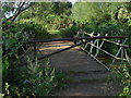
Footbridge over the Bourne
The concrete slab and scaffolding pole bridge over the Bourne which forms the boundary between Chertsey Meads and Hamm Court Farm.
Image: © Alan Hunt
Taken: 17 Aug 2012
0.18 miles
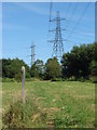
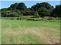
5
Fields, Hamm Court Farm
The footpath from Chertsey Meads crossing the fields of Hamm Court Farm towards Weybridge.
Image: © Alan Hunt
Taken: 17 Aug 2012
0.18 miles
6
Chertsey Meads
The southern edge of the Thames floodplain with the woods on Woburn Hill in the background.
Image: © Alan Hunt
Taken: 17 Aug 2012
0.21 miles
7
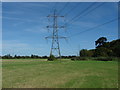
Chertsey Meads
One of the many pylon lines running from the major electricity sub-station near Brooklands industrial estate.
Image: © Alan Hunt
Taken: 17 Aug 2012
0.23 miles