IMAGES TAKEN NEAR TO
Harrow Close, ADDLESTONE, KT15 2GJ
Introduction
This page details the photographs taken nearby to Harrow Close, KT15 2GJ by members of the Geograph project.
The Geograph project started in 2005 with the aim of publishing, organising and preserving representative images for every square kilometre of Great Britain, Ireland and the Isle of Man.

There are currently over 7.5m images from over14,400 individuals and you can help contribute to the project by visiting https://www.geograph.org.uk
Image Map
Images are licensed for reuse under creativecommons.org/licenses/by-sa/2.0
Notes
- Clicking on the map will re-center to the selected point.
- The higher the marker number, the further away the image location is from the centre of the postcode.
Image Listing (14 Images Found)
Images are licensed for reuse under creativecommons.org/licenses/by-sa/2.0
Image
Details
Distance
1
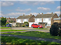
Houses on Roakes Avenue
Ten semi-detached houses are set back from the main street on a short stub. Four are seen here.
Image: © Robin Webster
Taken: 1 Oct 2015
0.08 miles
2
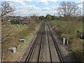
Railway Lines
The railway lines travelling south east from Chertsey towards Addlestone and Weybridge from the footbridge at the end of St John's Way.
Image: © Alan Hunt
Taken: 16 Apr 2012
0.10 miles
3
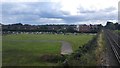
Chertsey Cemetery
Viewed from top of Railway Footbridge
Image: © James Emmans
Taken: 4 Aug 2016
0.16 miles
5
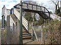
Iron footbridge
The iron footbridge that carries the footpath from Chertsey to Addlestone Moor over the railway.
Image: © Alan Hunt
Taken: 16 Apr 2012
0.18 miles
6
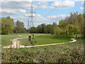
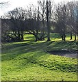
Abbey Moor golf club
A view of the golf course from the footpath that crosses Addlestone Moor.
Image: © Alan Hunt
Taken: 16 Apr 2012
0.18 miles
7
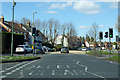
A317 Chertsey Road, Chertsey
Entering Chertsey from the Weybridge direction.
Image: © Robin Webster
Taken: 16 Mar 2020
0.19 miles
8
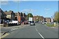
A317 approaching Clay Corner, Chertsey
Image: © Robin Webster
Taken: 16 Mar 2020
0.19 miles
9
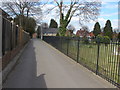
St John's Way, Chertsey
A view along St John's Way, a path that runs between the old cemetery and the new cemetery extension (on the right).
Image: © Alan Hunt
Taken: 16 Apr 2012
0.20 miles
10
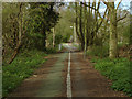
Footpath, Addlestone Moor
The footpath that runs from Eastworth Road in Chertsey to Green Lane,Addlestone with Addlestone Moor golf course on the right.
Image: © Alan Hunt
Taken: 16 Apr 2012
0.21 miles