IMAGES TAKEN NEAR TO
High Street, ADDLESTONE, KT15 1UB
Introduction
This page details the photographs taken nearby to High Street, KT15 1UB by members of the Geograph project.
The Geograph project started in 2005 with the aim of publishing, organising and preserving representative images for every square kilometre of Great Britain, Ireland and the Isle of Man.

There are currently over 7.5m images from over14,400 individuals and you can help contribute to the project by visiting https://www.geograph.org.uk
Image Map
Images are licensed for reuse under creativecommons.org/licenses/by-sa/2.0
Notes
- Clicking on the map will re-center to the selected point.
- The higher the marker number, the further away the image location is from the centre of the postcode.
Image Listing (20 Images Found)
Images are licensed for reuse under creativecommons.org/licenses/by-sa/2.0
Image
Details
Distance
2
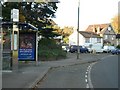
Bus stop in Chertsey Road, Addlestone
looking north
Image: © Andrew Longton
Taken: 1 Nov 2005
0.13 miles
6
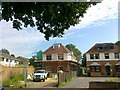
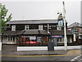
New house, Simplemarsh Road, Addlestone
Image: © Alex McGregor
Taken: 4 Jul 2011
0.16 miles
10
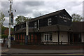
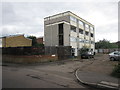
Addlestone: Pandrol Building, Station Road
The ground floor is occupied by two shops; Pandrol, who manufacture rail fastenings that fix rails to sleepers, occupies the rest of the building
Image: © Michael Garlick
Taken: 10 Jun 2013
0.21 miles