IMAGES TAKEN NEAR TO
Fieldhurst Close, ADDLESTONE, KT15 1NN
Introduction
This page details the photographs taken nearby to Fieldhurst Close, KT15 1NN by members of the Geograph project.
The Geograph project started in 2005 with the aim of publishing, organising and preserving representative images for every square kilometre of Great Britain, Ireland and the Isle of Man.

There are currently over 7.5m images from over14,400 individuals and you can help contribute to the project by visiting https://www.geograph.org.uk
Image Map
Images are licensed for reuse under creativecommons.org/licenses/by-sa/2.0
Notes
- Clicking on the map will re-center to the selected point.
- The higher the marker number, the further away the image location is from the centre of the postcode.
Image Listing (30 Images Found)
Images are licensed for reuse under creativecommons.org/licenses/by-sa/2.0
Image
Details
Distance
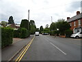
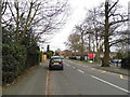
1
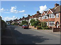
The Grove
Looking north along this 1920s residential street at the western end of Addlestone.
Image: © Alan Hunt
Taken: 22 Aug 2012
0.09 miles
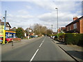
2
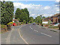
Liberty Lane
Looking east along Liberty Lane with the junction with The Grove on the left.
Image: © Alan Hunt
Taken: 22 Aug 2012
0.09 miles
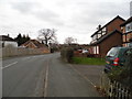
3
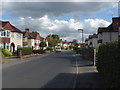
The Grove
View along The Grove. The houses mostly date to the 1920s.
Image: © Alan Hunt
Taken: 22 Aug 2012
0.10 miles
4
The Queens Arms, Addlestone
On Church Road.
See Image] for sign.
Image: © JThomas
Taken: 25 Jul 2022
0.11 miles
5
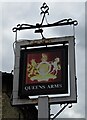
Sign for the Queens Arms, Addlestone
See Image] for public house.
Image: © JThomas
Taken: 25 Jul 2022
0.12 miles
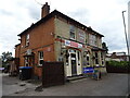
10
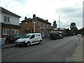
The Queen's Arms
A Victorian public house in Church road Addlestone.
Image: © Anthony Vosper
Taken: 1 Aug 2023
0.15 miles