IMAGES TAKEN NEAR TO
Rowtown, ADDLESTONE, KT15 1HJ
Introduction
This page details the photographs taken nearby to Rowtown, KT15 1HJ by members of the Geograph project.
The Geograph project started in 2005 with the aim of publishing, organising and preserving representative images for every square kilometre of Great Britain, Ireland and the Isle of Man.

There are currently over 7.5m images from over14,400 individuals and you can help contribute to the project by visiting https://www.geograph.org.uk
Image Map
Images are licensed for reuse under creativecommons.org/licenses/by-sa/2.0
Notes
- Clicking on the map will re-center to the selected point.
- The higher the marker number, the further away the image location is from the centre of the postcode.
Image Listing (9 Images Found)
Images are licensed for reuse under creativecommons.org/licenses/by-sa/2.0
Image
Details
Distance
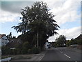
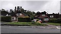
2
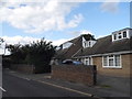
Row Town
It is the name of the road and the place
Image: © David Howard
Taken: 17 Aug 2014
0.10 miles
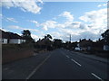
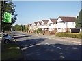
3
Franklands Drive at the junction of Row Town
Image: © David Howard
Taken: 17 Aug 2014
0.16 miles
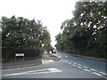
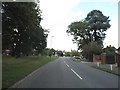
6
Hare Hill
Hare Hill, Row Hill, Addlestone.
Image: © Ajay Tegala
Taken: 20 Sep 2008
0.23 miles
7
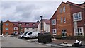
New Care Home Development on Rodwell Farm
Company Info : http://grahamcare.co.uk/the-homes/rodwell-farm/
Image: © James Emmans
Taken: 20 May 2016
0.24 miles
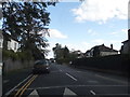
9
Hare Hill Junction with Row Hill - Row Town
Image: © James Emmans
Taken: 10 May 2016
0.24 miles