IMAGES TAKEN NEAR TO
Ongar Hill, ADDLESTONE, KT15 1BP
Introduction
This page details the photographs taken nearby to Ongar Hill, KT15 1BP by members of the Geograph project.
The Geograph project started in 2005 with the aim of publishing, organising and preserving representative images for every square kilometre of Great Britain, Ireland and the Isle of Man.

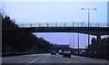
There are currently over 7.5m images from over14,400 individuals and you can help contribute to the project by visiting https://www.geograph.org.uk
Image Map
Images are licensed for reuse under creativecommons.org/licenses/by-sa/2.0
Notes
- Clicking on the map will re-center to the selected point.
- The higher the marker number, the further away the image location is from the centre of the postcode.
Image Listing (42 Images Found)
Images are licensed for reuse under creativecommons.org/licenses/by-sa/2.0
Image
Details
Distance
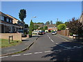
1
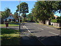
Liberty Rise
Liberty rise with the junction of Milton Road on the left.
Image: © Alan Hunt
Taken: 28 Aug 2012
0.08 miles
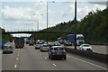
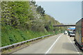
4
M25, Addlestone
Looking down on the M25 from a footbridge connecting Liberty Rise and Liberty Lane, Addlestone.
Image: © Ajay Tegala
Taken: 20 Sep 2008
0.11 miles
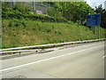
5
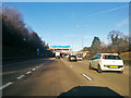
M25 clockwise
Next junction is 11, A320/A317 for Woking and Chertsey.
Image: © Robin Webster
Taken: 9 Dec 2017
0.11 miles
6
Ongar Close, Rowhill, near Addlestone
A side road near the point where the B3121 crosses the M25, just south of junction 11.
Image: © David Hawgood
Taken: 17 May 2006
0.11 miles
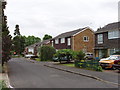
7
Avon Close
A short residential cul-de-sac in the housing estates to the west of the M25.
Image: © Alan Hunt
Taken: 28 Aug 2012
0.12 miles
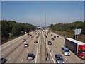
10
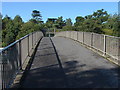
Footbridge over the M25
The footbridge between Liberty Rise and Liberty Lane in Addlestone. The sound barrier to shield the housing estates can be seen at the end of the bridge.
Image: © Alan Hunt
Taken: 28 Aug 2012
0.12 miles