IMAGES TAKEN NEAR TO
Fullerton Close, WEST BYFLEET, KT14 7SY
Introduction
This page details the photographs taken nearby to Fullerton Close, KT14 7SY by members of the Geograph project.
The Geograph project started in 2005 with the aim of publishing, organising and preserving representative images for every square kilometre of Great Britain, Ireland and the Isle of Man.

There are currently over 7.5m images from over14,400 individuals and you can help contribute to the project by visiting https://www.geograph.org.uk
Image Map
Images are licensed for reuse under creativecommons.org/licenses/by-sa/2.0
Notes
- Clicking on the map will re-center to the selected point.
- The higher the marker number, the further away the image location is from the centre of the postcode.
Image Listing (21 Images Found)
Images are licensed for reuse under creativecommons.org/licenses/by-sa/2.0
Image
Details
Distance
1
Ruston Road, Byfleet
One of the roads in the Manor Road Estate, developed during the late 1960s
Image: © Alan Hunt
Taken: 5 Mar 2013
0.04 miles
2
Ruston Road
The letterbox on the corner of Ruston Road and Cornwall Avenue in the Manor farm Estate
Image: © Alan Hunt
Taken: 5 Mar 2013
0.05 miles
4
Ulwyn Avenue
1950s council houses in Byfleet.
Image: © Burgess Von Thunen
Taken: 20 Jun 2012
0.16 miles
5
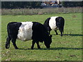
Belties in Byfleet
Belted Galloway cattle grazing on the Manor Farm Estate at Byfleet.
The breed seems to be more common in southern England nowadays.
Image: © Colin Smith
Taken: 6 Mar 2011
0.17 miles
6
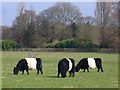
Byfleet Belties
Belted Galloway cattle grazing at Manor Farm Estate, Byfleet. The trees in the background are beside the River Wey.
www.weyriver.co.uk
Image: © Colin Smith
Taken: 6 Mar 2011
0.17 miles
7
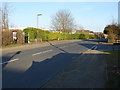
Celtic Road, Byfleet
Sanway Road with the junction of Sanway Close on the right. The former Manor school, now boarded up is behind the hedge on the left.
Image: © Alan Hunt
Taken: 5 Mar 2013
0.19 miles
8
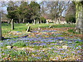
Byfleet Churchyard
Large graveyard on the southern side of ancient St Mary the Virgin, Byfleet's parish church. The early spring blue blooms are chionodoxa ("glory of the snow").
http://www.british-history.ac.uk/report.aspx?compid=42996
Image: © Colin Smith
Taken: 6 Mar 2011
0.19 miles
9
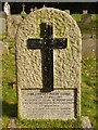
John Godfrey Parry Thomas
Memorial in Byfleet churchyard to a would be world record holder. Pendine Sands is far away in South Wales but Byfleet is very close to another mecca for speed - Brooklands.
http://www.british-history.ac.uk/report.aspx?compid=42996
Image: © Colin Smith
Taken: 6 Mar 2011
0.19 miles
10
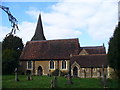
Byfleet Parish Church
Ancient St Mary the Virgin, seen from the south.
http://www.british-history.ac.uk/report.aspx?compid=42996
Image: © Colin Smith
Taken: 6 Mar 2011
0.20 miles