IMAGES TAKEN NEAR TO
Berrys Lane, WEST BYFLEET, KT14 7AU
Introduction
This page details the photographs taken nearby to Berrys Lane, KT14 7AU by members of the Geograph project.
The Geograph project started in 2005 with the aim of publishing, organising and preserving representative images for every square kilometre of Great Britain, Ireland and the Isle of Man.

There are currently over 7.5m images from over14,400 individuals and you can help contribute to the project by visiting https://www.geograph.org.uk
Image Map
Images are licensed for reuse under creativecommons.org/licenses/by-sa/2.0
Notes
- Clicking on the map will re-center to the selected point.
- The higher the marker number, the further away the image location is from the centre of the postcode.
Image Listing (37 Images Found)
Images are licensed for reuse under creativecommons.org/licenses/by-sa/2.0
Image
Details
Distance
1
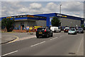
Business Park at Byfleet
Halfords Autocentre and Access self storage, beside the A318.
Image: © Peter Trimming
Taken: 24 Jun 2015
0.10 miles
2
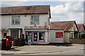
Newsagent at Byfleet
Located at the junction of Chertsey Road and the A318.
Image: © Peter Trimming
Taken: 24 Jun 2015
0.11 miles
3
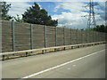
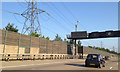
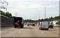
Pylon and noise barrier next to M25 anti-clockwise
Image: © Colin Pyle
Taken: 12 May 2014
0.11 miles
5
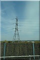
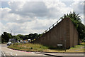
Timber and glass noise barrier, M25 northwest of Byfleet
The steel-framed noise barrier screens an industrial estate, a school, open space and a residential area to the east of the counter-clockwise carriageway. A close study of Where's the Path gives a precise location, whereas the camera phone puts this in the square to the north. The barrier appears to have been extended since the current aerial photo was taken.
Noise reduces with increasing distance from the source. Otherwise, noise can be reduced through absorption and reflection by a significant mass as close as possible to the source. The less dense the mass the more sound will be transmitted through the barrier. Tree-planting doesn't reduce noise but, by visually screening the source, can reduce the awareness or perception of noise by the public.
Image: © Robin Stott
Taken: 10 Jul 2013
0.12 miles
8
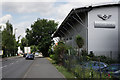
Bentley Surrey
Located beside the A318 at Byfleet.
Image: © Peter Trimming
Taken: 24 Jun 2015
0.17 miles
9
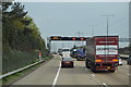
M25 anticlockwise
Past Byfleet Primary School and electricity pylons.
At marker 75.3
Image: © Julian P Guffogg
Taken: 13 Aug 2013
0.17 miles
10
Brooklands Race Track
The modern A318 road cuts through the banked track.
Brooklands was a 2.75-mile (4.43 km) motor racing circuit and aerodrome built near Weybridge in Surrey. It opened in 1907 and was the world's first purpose-built motor racing circuit as well as one of Britain's first airfields, which also became Britain's largest aircraft manufacturing centre by 1918. The circuit hosted its last race in 1939 and today part of it forms the Brooklands Museum, a major aviation and motoring museum, as well as a venue for vintage car, motorcycle and other transport-related events.
On 28–29 June 1907, eleven days after the circuit opened, it played host to the world's first 24-hour motor event, with Selwyn Edge leading three specially converted Napier cars around the circuit. During the event Edge covered a distance of 1,581.74 mi (2,545.56 km) at an average speed of 65.91 mph (106.07 km/h).
Selwyn Edge had been a rider with the Anerley Bicycle Club, before moving onto faster things.
Image: © Peter Trimming
Taken: 24 Jun 2015
0.18 miles