IMAGES TAKEN NEAR TO
Chertsey Road, WEST BYFLEET, KT14 7AF
Introduction
This page details the photographs taken nearby to Chertsey Road, KT14 7AF by members of the Geograph project.
The Geograph project started in 2005 with the aim of publishing, organising and preserving representative images for every square kilometre of Great Britain, Ireland and the Isle of Man.

There are currently over 7.5m images from over14,400 individuals and you can help contribute to the project by visiting https://www.geograph.org.uk
Image Map
Images are licensed for reuse under creativecommons.org/licenses/by-sa/2.0
Notes
- Clicking on the map will re-center to the selected point.
- The higher the marker number, the further away the image location is from the centre of the postcode.
Image Listing (52 Images Found)
Images are licensed for reuse under creativecommons.org/licenses/by-sa/2.0
Image
Details
Distance
1
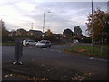
Junction of Parvis Road and Chertsey Road, Byfleet
Image: © David Howard
Taken: 31 Oct 2011
0.10 miles
2
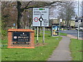
Welcome to Byfleet
Village sign beside Parvis Road, the main approach road from the west. Other signs add clutter to the scene. How many motorists take them all in as they drive by?
Image: © Colin Smith
Taken: 6 Mar 2011
0.11 miles
3
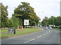
The approach to Byfleet from the west along Parvis Road
Image: © Andrew Longton
Taken: 11 Oct 2005
0.14 miles
4
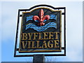
Byfleet Village
Village sign in central Byfleet. The village lies by the River Wey and once had a royal manor house.
http://www.british-history.ac.uk/report.aspx?compid=42996
Image: © Colin Smith
Taken: 6 Mar 2011
0.14 miles
5
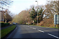
A245 Parvis Road heading west
Passing through Byfleet towards West Byfleet.
Image: © Robin Webster
Taken: 8 Dec 2019
0.15 miles
6
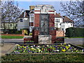
Byfleet War Memorial
Red brick cenotaph with formal flower beds around it in central Byfleet.
Image: © Colin Smith
Taken: 6 Mar 2011
0.15 miles
7
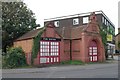
Byfleet old fire station
Byfleet old fire station, High Road, Byfleet, Surrey
Image: © Kevin Hale
Taken: 6 Oct 2007
0.15 miles
8
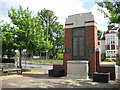
Byfleet: The War Memorial
The War Memorial is at the eastern end of the triangle of land between Parvis Road and the High Road.
(NB From a Geograph point of view the Ordnance Survey 1:10,000 scale mapping puts the memorial about 10 metres west of the 506000 Easting gridline.)
Image: © Nigel Cox
Taken: 20 May 2008
0.17 miles
9
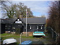
Here is the BBC
Not THE BBC but another BBC, this time it is the Byfleet Boat Club. This boat house is located on the east bank of the River Wey Navigation, north of the Parvis Road Bridge.
www.weyriver.co.uk
Image: © Colin Smith
Taken: 6 Mar 2011
0.17 miles
10
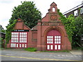
Byfleet: The old Fire Station
A photograph to complement Kevin's Image, this shows the front elevation square on, with the terracotta plaque above the doors on the right stating that it was erected in 1885, and possibly a small bell tower above. The fire station was closed around 1960.
There is a group that is interested in preserving the fire station with a website here http://www.byfleetfirestation.com/index.html
although, as they say, refurbishment will cost a lot of money and just what can you do with an old fire station without changing the original character of the building entirely?
Image: © Nigel Cox
Taken: 20 May 2008
0.17 miles