IMAGES TAKEN NEAR TO
Bridgewater Road, WEYBRIDGE, KT13 0EE
Introduction
This page details the photographs taken nearby to Bridgewater Road, KT13 0EE by members of the Geograph project.
The Geograph project started in 2005 with the aim of publishing, organising and preserving representative images for every square kilometre of Great Britain, Ireland and the Isle of Man.

There are currently over 7.5m images from over14,400 individuals and you can help contribute to the project by visiting https://www.geograph.org.uk
Image Map
Images are licensed for reuse under creativecommons.org/licenses/by-sa/2.0
Notes
- Clicking on the map will re-center to the selected point.
- The higher the marker number, the further away the image location is from the centre of the postcode.
Image Listing (6 Images Found)
Images are licensed for reuse under creativecommons.org/licenses/by-sa/2.0
Image
Details
Distance
4
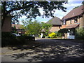
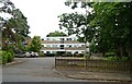
Sorbie Close
Modern development in Weybridge.
Image: © David Howard
Taken: 31 May 2009
0.17 miles
5
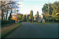
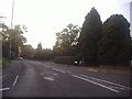
A317 to Weybridge
Leaving the sort of roundabout at the junction with the B365.
Image: © Robin Webster
Taken: 25 Nov 2017
0.18 miles