IMAGES TAKEN NEAR TO
Southdown Road, WALTON-ON-THAMES, KT12 4PJ
Introduction
This page details the photographs taken nearby to Southdown Road, KT12 4PJ by members of the Geograph project.
The Geograph project started in 2005 with the aim of publishing, organising and preserving representative images for every square kilometre of Great Britain, Ireland and the Isle of Man.

There are currently over 7.5m images from over14,400 individuals and you can help contribute to the project by visiting https://www.geograph.org.uk
Image Map
Images are licensed for reuse under creativecommons.org/licenses/by-sa/2.0
Notes
- Clicking on the map will re-center to the selected point.
- The higher the marker number, the further away the image location is from the centre of the postcode.
Image Listing (20 Images Found)
Images are licensed for reuse under creativecommons.org/licenses/by-sa/2.0
Image
Details
Distance
3
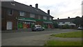
Londis Convenience Store
Longmore Estate was built in the 1950's and the store has recently been renovated from two older stores. The estate is on the Molesey Road and there are plans to build another estate not far down the road on a disused gravel pit.
Image: © James Emmans
Taken: 20 Jun 2014
0.10 miles

8
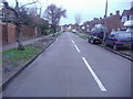
A244 Esher Road, Hersham
By the Riverside Road bus stops.
Image: © Robin Webster
Taken: 24 Aug 2012
0.13 miles
9
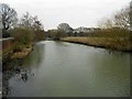
River Mole: Looking downstream from Old Esher Road in Hersham
The river here is in places over 20 metres wide.
Image: © Nigel Cox
Taken: 27 Feb 2016
0.14 miles