IMAGES TAKEN NEAR TO
Field Common Lane, WALTON-ON-THAMES, KT12 3QH
Introduction
This page details the photographs taken nearby to Field Common Lane, KT12 3QH by members of the Geograph project.
The Geograph project started in 2005 with the aim of publishing, organising and preserving representative images for every square kilometre of Great Britain, Ireland and the Isle of Man.

There are currently over 7.5m images from over14,400 individuals and you can help contribute to the project by visiting https://www.geograph.org.uk
Image Map
Images are licensed for reuse under creativecommons.org/licenses/by-sa/2.0
Notes
- Clicking on the map will re-center to the selected point.
- The higher the marker number, the further away the image location is from the centre of the postcode.
Image Listing (14 Images Found)
Images are licensed for reuse under creativecommons.org/licenses/by-sa/2.0
Image
Details
Distance
3
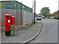
Postbox, corner of Homefield Road and Fieldcommon Lane
Image: © Robin Webster
Taken: 1 Sep 2012
0.09 miles
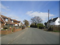
6
Junction of Fieldcommon Lane with Molesey Road
looking northeast
Image: © Andrew Longton
Taken: 11 Oct 2005
0.14 miles
8
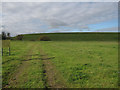
Queen Elizabeth II reservoir
Associated with Walton water treatment works. This area is flat but has good supplies of clay for bunds so reservoirs are raised up above the surrounding land.
Image: © Hugh Venables
Taken: 6 Nov 2010
0.15 miles
10
Junction of Rydens Road and Molesey Road
Image: © David Howard
Taken: 17 Oct 2011
0.16 miles