IMAGES TAKEN NEAR TO
Waterside Drive, WALTON-ON-THAMES, KT12 2HZ
Introduction
This page details the photographs taken nearby to Waterside Drive, KT12 2HZ by members of the Geograph project.
The Geograph project started in 2005 with the aim of publishing, organising and preserving representative images for every square kilometre of Great Britain, Ireland and the Isle of Man.

There are currently over 7.5m images from over14,400 individuals and you can help contribute to the project by visiting https://www.geograph.org.uk
Image Map
Images are licensed for reuse under creativecommons.org/licenses/by-sa/2.0
Notes
- Clicking on the map will re-center to the selected point.
- The higher the marker number, the further away the image location is from the centre of the postcode.
Image Listing (216 Images Found)
Images are licensed for reuse under creativecommons.org/licenses/by-sa/2.0
Image
Details
Distance
1
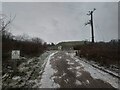
Access road to the fuel storage company
The tops of the underground storage tanks are straight ahead. They must be designed against terrorist bombs and wartime bombing.
Image: © James Emmans
Taken: 8 Feb 2021
0.01 miles
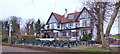
2
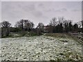
Grassland close to The Weir Hotel and Pub
This grassland is between the CLH fuel storage area and the Sports Hub.
Hotel Website : https://www.weirhotel.co.uk/
Image: © James Emmans
Taken: 8 Feb 2021
0.05 miles
3
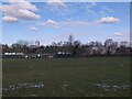
Apps Court border field with CLH PL Facilities
This storage and pipeline facility is part of a national underground network. In 1959 a pipeline and storage tanks were added here for Heathrow and Gatwick from the Isle of Grain London.
Image: © James Emmans
Taken: 10 Feb 2021
0.05 miles
4
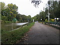
Thames Path
Thames Path by The Weir public house
Image: © Shaun Ferguson
Taken: 9 Oct 2012
0.06 miles
5
The Weir Hotel, River Thames
The Weir Hotel is sited at the entrance to the channel leading to the Sunbury Locks. For a view of the location of the original lock refer to picture Image
Image: © Len Williams
Taken: 11 Feb 2015
0.07 miles
6
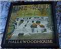
Pub Sign at The Weir Hotel
This hotel / pub overlooks Sunbury Weir from the south bank of the River Thames. The sign looks nothing like the nearby weir, see https://www.geograph.org.uk/photo/232709 The Weir Hotel is visible at the link. This is on the Thames Path National Trail and on the route of the London Green Belt Way.
Image: © Sean Davis
Taken: 1 Jan 1999
0.07 miles
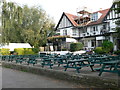
7

Thames Path past The Weir Hotel
To the left is the beer garden and sign of The Weir Hotel. To the right is the River Thames and the weir. This is also on the route of the London Green Belt Way.
Image: © Sean Davis
Taken: 25 Jun 2007
0.07 miles
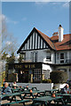
8
The Weir Hotel, Walton on Thames
The hotel overlooks the Thames near Sunbury Weir. The Thames Path passes in front of it along the towpath.
Image: © Eirian Evans
Taken: 13 Oct 2011
0.07 miles
10
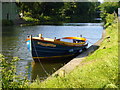
Tasteful Boat by Thames Path
"Seamus Thierry" boat parked up outside The Weir Hotel.
Image: © Sean Davis
Taken: 25 Jun 2007
0.08 miles