IMAGES TAKEN NEAR TO
Hurst Road, WALTON-ON-THAMES, KT12 2EG
Introduction
This page details the photographs taken nearby to Hurst Road, KT12 2EG by members of the Geograph project.
The Geograph project started in 2005 with the aim of publishing, organising and preserving representative images for every square kilometre of Great Britain, Ireland and the Isle of Man.

There are currently over 7.5m images from over14,400 individuals and you can help contribute to the project by visiting https://www.geograph.org.uk
Image Map
Images are licensed for reuse under creativecommons.org/licenses/by-sa/2.0
Notes
- Clicking on the map will re-center to the selected point.
- The higher the marker number, the further away the image location is from the centre of the postcode.
Image Listing (26 Images Found)
Images are licensed for reuse under creativecommons.org/licenses/by-sa/2.0
Image
Details
Distance
1
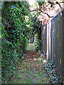
Footpath west of Walton on Thames Water Works
Image: © Mike Quinn
Taken: 6 Jun 2018
0.05 miles
2
Apps Court Farm, West Molesey
The pay and display car park for the Hampton Court flower show at Apps Court Farm.
Image: © Alan Hunt
Taken: 7 Jul 2016
0.09 miles
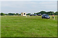
5
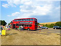
Park and ride terminus at Apps Court Farm
During Hampton Court Flower Show.
Image: © Rod Allday
Taken: 5 Jul 2018
0.13 miles
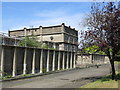
6
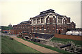
Walton Pumping station
Thames Water public water supply pumping station. Built 1911 and extended (foreground) in 1926. Houses a preserved steam engine.
Image: © Chris Allen
Taken: 13 Apr 1993
0.13 miles
7
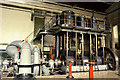
Pumping engine Walton Pumping Station
The survivor of four Thames Ironworks engines from 1911. To the right is the 1926 extension that housed a huge triple expansion steam pump and a steam turbine set.
Image: © Chris Allen
Taken: 13 Apr 1993
0.13 miles
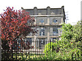
8
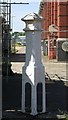
Coal tax boundary post no.100b, Walton on Thames Water Works
The location of this post is shown in Image and Image
This post was originally to the west of Island Barn Reservoir on the east bank of the former course of the River Mole, around 250 metres north of its divergence from the River Ember. It was moved to the Water Works in 1977. It has been temporarily taken out of the ground during renovation works - showing the lower part of the post that is usually buried underground.
There are over 200 coal tax posts located around London, most of which are 3 ft high white-painted bollards http://www.geograph.org.uk/search.php?i=86542993&page=1 . The posts were erected under the Coal and Wine Duties (Continuation) Act of 1861 to mark the points at which duty had to be paid on coal being transported to London. The boundary was set at that of the Metropolitan Police District, and the resulting revenue was used by the Corporation of the City of London to fund public works. For further info see http://www.coaldutyposts.org.uk/cityposts.html .
Image: © Mike Quinn
Taken: 6 Jun 2018
0.15 miles
9
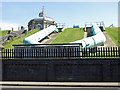
Outlet pipes from Bessborough and Knight Reservoirs
Image: © Mike Quinn
Taken: 6 Jun 2018
0.15 miles
10
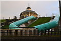
Reservoir valve house and outlet pipes
Image: © David Martin
Taken: 28 Oct 2013
0.16 miles