IMAGES TAKEN NEAR TO
Monks Crescent, WALTON-ON-THAMES, KT12 2AH
Introduction
This page details the photographs taken nearby to Monks Crescent, KT12 2AH by members of the Geograph project.
The Geograph project started in 2005 with the aim of publishing, organising and preserving representative images for every square kilometre of Great Britain, Ireland and the Isle of Man.

There are currently over 7.5m images from over14,400 individuals and you can help contribute to the project by visiting https://www.geograph.org.uk
Image Map
Images are licensed for reuse under creativecommons.org/licenses/by-sa/2.0
Notes
- Clicking on the map will re-center to the selected point.
- The higher the marker number, the further away the image location is from the centre of the postcode.
Image Listing (12 Images Found)
Images are licensed for reuse under creativecommons.org/licenses/by-sa/2.0
Image
Details
Distance
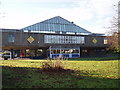
6
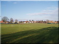
Recreation ground
Near Walton swimming pool
Image: © Oliver White
Taken: 24 Dec 2005
0.23 miles
7
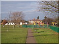
View to Walton
From the recreation ground, looking towards church
Image: © Oliver White
Taken: 25 Dec 2005
0.23 miles
8
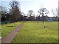
Recreation ground
With swimming pool off the left of the picture
Image: © Oliver White
Taken: 25 Dec 2005
0.23 miles
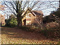
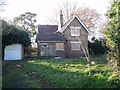
9

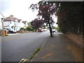
Kings Road
Walton on Thames residential street now a cul de sac.
Image: © James Emmans
Taken: 23 Jun 2014
0.24 miles
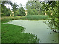
10
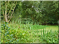
Pond, small park by Shaw Drive
The blue flowers look like Pickerel Weed, a garden plant of American origin. It is rather invasive, as are other plants in this pond.
Image: © Robin Webster
Taken: 1 Sep 2012
0.24 miles