IMAGES TAKEN NEAR TO
Ashley Rise, WALTON-ON-THAMES, KT12 1ND
Introduction
This page details the photographs taken nearby to Ashley Rise, KT12 1ND by members of the Geograph project.
The Geograph project started in 2005 with the aim of publishing, organising and preserving representative images for every square kilometre of Great Britain, Ireland and the Isle of Man.

There are currently over 7.5m images from over14,400 individuals and you can help contribute to the project by visiting https://www.geograph.org.uk
Image Map
Images are licensed for reuse under creativecommons.org/licenses/by-sa/2.0
Notes
- Clicking on the map will re-center to the selected point.
- The higher the marker number, the further away the image location is from the centre of the postcode.
Image Listing (16 Images Found)
Images are licensed for reuse under creativecommons.org/licenses/by-sa/2.0
Image
Details
Distance
1
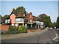
Walton-on-Thames: The Ashley Park Hotel
Originally the Victorian hotel serving Walton-on-Thames station, which is behind the photographer, this is now the Ember Pub and Dining Ashley Park http://www.emberpubanddining.co.uk/theashleyparkwaltononthames/. However the building has not lost its original purpose as Travelodge have recently opened a new facility adjacent to the hotel, but out of sight at the end http://www.travelodge.co.uk/hotels/info?hotelId=488
Image: © Nigel Cox
Taken: 23 Oct 2011
0.20 miles
2

Walton-on-Thames: Cornerstone the Church
This prominent building opposite Walton-on-Thames railway station appears to be being constructed for the Cornerstone the Church whose website is here http://cornerstonethechurch.com/Groups/93929/Cornerstone_the_Church.aspx
Old Ordnance Survey large scale maps show that this was once the site of a garage.
Image: © Nigel Cox
Taken: 23 Oct 2011
0.20 miles
3
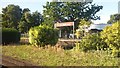
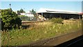
Do not alight here
Sign on disused and rather overgrown island platform at Walton on Thames station.
Image: © David Martin
Taken: 3 Oct 2016
0.22 miles
4
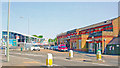
Walton-on-Thames Station, Up side entrance
View eastward on Station Avenue, towards Surbiton and London: ex-LSWR Waterloo - Woking and the West main line.
Image: © Ben Brooksbank
Taken: 30 Apr 2007
0.22 miles
5
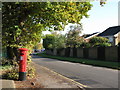
Edward VIII postbox, Mayfield Road
Image: © Mike Quinn
Taken: 29 Oct 2008
0.22 miles
6
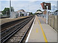
Walton on Thames railway station, Surrey
Opened in 1838 by the London & Southampton Railway. View south west towards Weybridge and Woking.
Image: © Nigel Thompson
Taken: 3 Aug 2010
0.23 miles
7
Disused island platform at Walton on Thames station
Image: © David Martin
Taken: 3 Oct 2016
0.23 miles
8
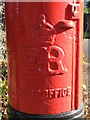
Edward VIII postbox, Mayfield Road - royal cipher
See Image
Image: © Mike Quinn
Taken: 29 Oct 2008
0.23 miles
9

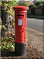
Walton-on-Thames: postbox № KT12 158, Mayfield Road
One of few pillar boxes to be cast during the short reign of Edward VIII - there are 80 or so still in use. This one is in Mayfield Road and is emptied finally at 5:15pm on weekdays and at 11:45am on Saturdays.
See Image for a close-up of the cipher.
Image: © Chris Downer
Taken: 18 Jan 2014
0.23 miles