IMAGES TAKEN NEAR TO
Bridge Street, WALTON-ON-THAMES, KT12 1BT
Introduction
This page details the photographs taken nearby to Bridge Street, KT12 1BT by members of the Geograph project.
The Geograph project started in 2005 with the aim of publishing, organising and preserving representative images for every square kilometre of Great Britain, Ireland and the Isle of Man.

There are currently over 7.5m images from over14,400 individuals and you can help contribute to the project by visiting https://www.geograph.org.uk
Image Map (Loading...)


Getting Data...Please wait
Leaflet Map data © OpenStreetMap
Images are licensed for reuse under creativecommons.org/licenses/by-sa/2.0
Notes
- Clicking on the map will re-center to the selected point.
- The higher the marker number, the further away the image location is from the centre of the postcode.
Image Listing (103 Images Found)
Images are licensed for reuse under creativecommons.org/licenses/by-sa/2.0
Image
Details
Distance
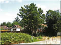
1
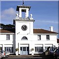
Clock Tower at Mount Felix
Mount Felix, a large mansion overlooking the Thames near Walton Bridge, was rebuilt in the middle of the 19th century by Sir Charles Barry for the 5th Earl of Tankerville. However it was taken over by the New Zealand War Contingent Association in 1915 and converted to a hospital for New Zealand war victims. It was called New Zealand General Hospital No. 2 (No. 1 was at Brockenhurst in the New Forest). At its peak it had over 1,000 beds and continued till after the end of the war until late June 1919.
During their time at Walton the New Zealand soldiers had many fond memories of the town. One New Zealand medical officer wrote:
"The grounds at Walton (which ran down to the Thames) were delightful with beautiful walks, flower beds and green fields. The garden was well kept, and the fine old English cedars and other trees lent a peculiar charm to the surroundings".
Over 27,000 New Zealanders were cared for here during the Great War. The people of Walton took the young soldiers into their homes and their hearts, and in 1921 a plaque was erected to remember them. In 1966 Mount Felix was badly damaged by a fire and had to be demolished.
All that now remains of Mount Felix is this Clock Tower on Bridge Close which has been converted to office use and the gate pillars on Bridge Street at the junction of Hepworth Way.
Image: © Sean Davis
Taken: 15 Feb 2007
0.04 miles
2
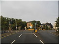
Oatlands Drive at the junction of New Zealand Avenue
Image: © David Howard
Taken: 24 Aug 2013
0.05 miles
3
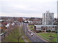
Hepworth Way
From the roof of the new Sainsbury's car park
Image: © Oliver White
Taken: 22 Dec 2005
0.06 miles
5
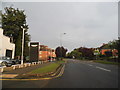
Bridge Street / Ridgeway
Shows the location of Image
Image: © Mike Quinn
Taken: 11 Jul 2018
0.06 miles
6
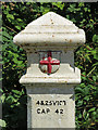
Coal tax boundary post no.94, Bridge Street (A244) (detail)
See Image
Image: © Mike Quinn
Taken: 11 Jul 2018
0.07 miles
7
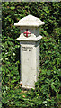
Coal tax boundary post no.94, Bridge Street (A244)
The location of this post is shown in Image and Image
The post is Grade II listed https://historicengland.org.uk/listing/the-list/list-entry/1192307 .
There are over 200 coal tax posts located around London, most of which are 3 ft high white-painted bollards http://www.geograph.org.uk/search.php?i=86542993&page=1 . The posts were erected under the Coal and Wine Duties (Continuation) Act of 1861 to mark the points at which duty had to be paid on coal being transported to London. The boundary was set at that of the Metropolitan Police District, and the resulting revenue was used by the Corporation of the City of London to fund public works. For further info see http://www.coaldutyposts.org.uk/cityposts.html .
Image: © Mike Quinn
Taken: 11 Jul 2018
0.08 miles
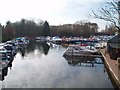
8

Walton Marina
Storefront of Walton Marina, as seen from the Thames Path
Image: © Oliver White
Taken: 24 Dec 2005
0.09 miles
10
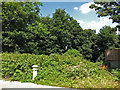
Wooded area north of Bridge Street
Shows the location of Image
Image: © Mike Quinn
Taken: 11 Jul 2018
0.09 miles