IMAGES TAKEN NEAR TO
Woodlands Lane, COBHAM, KT11 3PZ
Introduction
This page details the photographs taken nearby to Woodlands Lane, KT11 3PZ by members of the Geograph project.
The Geograph project started in 2005 with the aim of publishing, organising and preserving representative images for every square kilometre of Great Britain, Ireland and the Isle of Man.

There are currently over 7.5m images from over14,400 individuals and you can help contribute to the project by visiting https://www.geograph.org.uk
Image Map
Images are licensed for reuse under creativecommons.org/licenses/by-sa/2.0
Notes
- Clicking on the map will re-center to the selected point.
- The higher the marker number, the further away the image location is from the centre of the postcode.
Image Listing (8 Images Found)
Images are licensed for reuse under creativecommons.org/licenses/by-sa/2.0
Image
Details
Distance
1
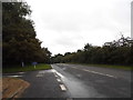
Woodlands Road by Leatherhead Court
Currently the home of QEF Vocational Services
Image: © David Howard
Taken: 1 Sep 2014
0.12 miles
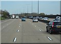
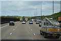
6
M25, Woodlands Park
Heading east (anticlockwise).
Image: © JThomas
Taken: 5 Mar 2012
0.20 miles
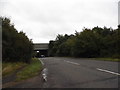
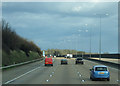
7

M25 anti-clockwise sign near Woodlands Park
Image: © Colin Pyle
Taken: 13 May 2013
0.24 miles
8
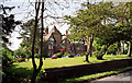
Woodlands Park, Stoke d'Abernon
A sprawling Victorian house bristling with the usual panoply of towers, gables and chimneys, not to mention some bonus half-timbering. By Rowland Plumbe, 1886, for F.C. Bryant (of Bryant & May fame). Grade II listed.
Now the eponymous hotel.
The date of the photo is uncertain.
Image: © Stephen Richards
Taken: Unknown
0.24 miles