IMAGES TAKEN NEAR TO
Chilbrook Road, COBHAM, KT11 3PE
Introduction
This page details the photographs taken nearby to Chilbrook Road, KT11 3PE by members of the Geograph project.
The Geograph project started in 2005 with the aim of publishing, organising and preserving representative images for every square kilometre of Great Britain, Ireland and the Isle of Man.

There are currently over 7.5m images from over14,400 individuals and you can help contribute to the project by visiting https://www.geograph.org.uk
Image Map
Images are licensed for reuse under creativecommons.org/licenses/by-sa/2.0
Notes
- Clicking on the map will re-center to the selected point.
- The higher the marker number, the further away the image location is from the centre of the postcode.
Image Listing (22 Images Found)
Images are licensed for reuse under creativecommons.org/licenses/by-sa/2.0
Image
Details
Distance
1

Chilbrook Farm
The entrance to Chilbrook Farm on Chilbrook Road, a rural road in the countryside between Cobham and Downside.
Image: © Alan Hunt
Taken: 4 May 2016
0.03 miles
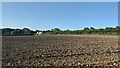
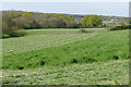
3
Fields off Chilbrook Road
The view northeast from Chilbrook Road towards Cossins House on Downside Road.
Image: © Alan Hunt
Taken: 4 May 2016
0.11 miles
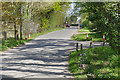
4
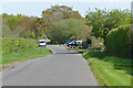
Chilbrook Road, Downside
Looking southeast along Chilbrook Road with Forge Cottages on the right by the vehicles.
Image: © Alan Hunt
Taken: 4 May 2016
0.13 miles
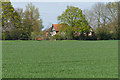
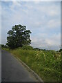
5

Hedgerow oak, Chilbrook Road
An oak coming into leaf beside Chilbrook Road in Downside.
Image: © Alan Hunt
Taken: 4 May 2016
0.17 miles
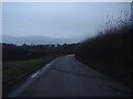
7
Chilbrook Road, Downside
Chilbrook Road near Cobham with the entrance to Pondtail Farm on the right.
Image: © Alan Hunt
Taken: 4 May 2016
0.17 miles
9
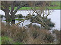
Flooding by Plough Lane
The field edge is very wet after heavy spells of rain. The soil is poor draining clay and is adjacent to the River Mole.
Image: © Colin Smith
Taken: 27 Feb 2011
0.20 miles
10
View from the Downside Way near Cobham
Looking in the direction of Cobham from the top of the hill above Pondtail Farm in Downside.
Image: © Alan Hunt
Taken: 4 May 2016
0.21 miles