IMAGES TAKEN NEAR TO
Downside Road, COBHAM, KT11 3LY
Introduction
This page details the photographs taken nearby to Downside Road, KT11 3LY by members of the Geograph project.
The Geograph project started in 2005 with the aim of publishing, organising and preserving representative images for every square kilometre of Great Britain, Ireland and the Isle of Man.

There are currently over 7.5m images from over14,400 individuals and you can help contribute to the project by visiting https://www.geograph.org.uk
Image Map
Images are licensed for reuse under creativecommons.org/licenses/by-sa/2.0
Notes
- Clicking on the map will re-center to the selected point.
- The higher the marker number, the further away the image location is from the centre of the postcode.
Image Listing (29 Images Found)
Images are licensed for reuse under creativecommons.org/licenses/by-sa/2.0
Image
Details
Distance
1
The Medicine Garden, Cobham
The Medicine Garden was converted from a stud farm in 2011 and sells plants and food as well as offering a variety of treatments and small shops. The cafe is on the left of the wall and the shops are behind it in the old stable.
Image: © David Howard
Taken: 12 Mar 2012
0.01 miles
2
The Medicine Garden, Cobham
The Medicine Garden was converted from a stud farm in 2011 and sells plants and food as well as offering a variety of treatments and small shops.
Image: © David Howard
Taken: 12 Mar 2012
0.01 miles
3
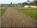
Fields by Downside Road, Cobham
Brussels sprouts are the only visible crop in the middle.
Image: © David Howard
Taken: 12 Mar 2012
0.04 miles
4
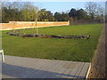
Crop field in Cobham
Brussels sprouts are growing on the left but nothing is visible yet in the other rows.
Image: © David Howard
Taken: 12 Mar 2012
0.04 miles
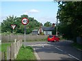
5

Telegraph pole on Downside Road
With more and more electricity cables going underground these wooden poles are becoming rarer nowadays, especially in towns.
Image: © David Howard
Taken: 27 Nov 2011
0.09 miles
6
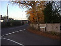
Junction of Cobham Park Road and Downside Road
Image: © David Howard
Taken: 27 Nov 2011
0.09 miles
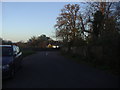
7
Junction of Cobham Park Road (foreground) and Downside Road
Looking north-west.
Image: © Andrew Longton
Taken: 8 Sep 2005
0.09 miles
8
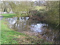
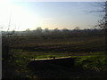
Pond at Downside
Duck pond nestling within the fork of Cobham Park and Downside roads, south of Cobham.
Image: © Colin Smith
Taken: 27 Feb 2011
0.11 miles
9
Cobham Park Road looking to Downside Road, Cobham
Image: © David Howard
Taken: 27 Nov 2011
0.11 miles
10
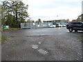
Car park by Downside Road, Cobham
Serving Challenge Fencing opposite and the Medicine Garden behind
Image: © David Howard
Taken: 3 Nov 2014
0.11 miles