IMAGES TAKEN NEAR TO
Downside Bridge Road, COBHAM, KT11 3LW
Introduction
This page details the photographs taken nearby to Downside Bridge Road, KT11 3LW by members of the Geograph project.
The Geograph project started in 2005 with the aim of publishing, organising and preserving representative images for every square kilometre of Great Britain, Ireland and the Isle of Man.

There are currently over 7.5m images from over14,400 individuals and you can help contribute to the project by visiting https://www.geograph.org.uk
Image Map
Images are licensed for reuse under creativecommons.org/licenses/by-sa/2.0
Notes
- Clicking on the map will re-center to the selected point.
- The higher the marker number, the further away the image location is from the centre of the postcode.
Image Listing (6 Images Found)
Images are licensed for reuse under creativecommons.org/licenses/by-sa/2.0
Image
Details
Distance
2
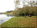
Fisherman Opposite The Lake
Taken from the Painshill Park footpath around the lake.
Image: © James Emmans
Taken: 9 Nov 2017
0.18 miles
4
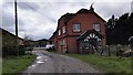
Boathouse on The Lake
Footpath next to Wood Hill in Painshill Park.
Image: © James Emmans
Taken: 9 Nov 2017
0.23 miles
6
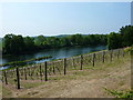
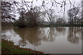
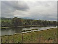
Vineyard and lake at Painshill Park
The park is a Grade 1 listed landscape created by Charles Hamilton in the eighteenth century. The vineyard produces grapes for white, rosé and sparkling wine.
Image: © pam fray
Taken: 25 May 2010
0.24 miles