IMAGES TAKEN NEAR TO
D'Abernon Drive, COBHAM, KT11 3JE
Introduction
This page details the photographs taken nearby to D'Abernon Drive, KT11 3JE by members of the Geograph project.
The Geograph project started in 2005 with the aim of publishing, organising and preserving representative images for every square kilometre of Great Britain, Ireland and the Isle of Man.

There are currently over 7.5m images from over14,400 individuals and you can help contribute to the project by visiting https://www.geograph.org.uk
Image Map
Images are licensed for reuse under creativecommons.org/licenses/by-sa/2.0
Notes
- Clicking on the map will re-center to the selected point.
- The higher the marker number, the further away the image location is from the centre of the postcode.
Image Listing (32 Images Found)
Images are licensed for reuse under creativecommons.org/licenses/by-sa/2.0
Image
Details
Distance
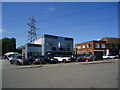
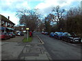
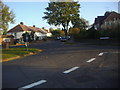
2
Roundabout on D'Abernon Drive, Stoke D'Abernon
Image: © David Howard
Taken: 19 Oct 2009
0.08 miles
3
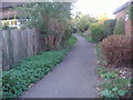
Footpath off Bray Road, Stoke D'Abernon
Image: © David Howard
Taken: 19 Oct 2009
0.08 miles
4
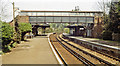
Cobham & Stoke d'Abernon station, 1984
View NE, towards Surbiton and Waterloo: ex-LSWR Waterloo - Surbiton - Guildford line. ('& Stoke d'Abernon' had been added to the name only from 9/9/51). This is the epitome of the 'Leafy Surrey suburbs of London').
Image: © Ben Brooksbank
Taken: 20 Apr 1984
0.09 miles
6
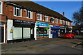
Station Road, Stoke D'Abernon
Looking towards the main part of the village past the inevitable parade of shops, with Cobham & Stoke D'Abernon railway station behind the photographer.
Image: © Richard Vince
Taken: 14 Dec 2024
0.10 miles
7
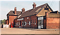
Cobham & Stoke d'Abernon station, exterior, 1984
View NE, towards Surbiton and Waterloo: ex-LSWR Waterloo - Surbiton - Guildford line. ('Stoke d'Abernon' was added from 9/51).
Image: © Ben Brooksbank
Taken: 29 Apr 1984
0.10 miles
8
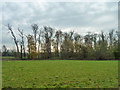
Shaw by the Mole, Stoke D'Abernon
The river runs the other side of the trees. There were some very noisy Ring-necked Parakeets here. These birds are now very common in south London and its environs.
Image: © Robin Webster
Taken: 21 Nov 2011
0.10 miles
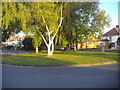
9
Roundabout at junction of Bray Road and D'Abernon Drive
Stoke D'Abernon
Image: © David Howard
Taken: 19 Oct 2009
0.10 miles
10

Ash bridge
Ash bridge carries River Lane, a public bridleway (Esher 82), over the River Mole at Stoke d'Abernon. Until the 1990s, there was only a ford here, and the path could be followed only by horseriders or the more intrepid walkers.
Image: © Hugh Craddock
Taken: 26 Apr 2008
0.11 miles