IMAGES TAKEN NEAR TO
Tilt Road, COBHAM, KT11 3HP
Introduction
This page details the photographs taken nearby to Tilt Road, KT11 3HP by members of the Geograph project.
The Geograph project started in 2005 with the aim of publishing, organising and preserving representative images for every square kilometre of Great Britain, Ireland and the Isle of Man.

There are currently over 7.5m images from over14,400 individuals and you can help contribute to the project by visiting https://www.geograph.org.uk
Image Map
Images are licensed for reuse under creativecommons.org/licenses/by-sa/2.0
Notes
- Clicking on the map will re-center to the selected point.
- The higher the marker number, the further away the image location is from the centre of the postcode.
Image Listing (19 Images Found)
Images are licensed for reuse under creativecommons.org/licenses/by-sa/2.0
Image
Details
Distance
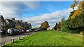
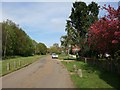
2
Cobham Tilt and Korea Cottages
Cobham Tilt is on the east side of Cobham, and has the appearance of a traditional green at the side of Tilt Road. However, the road is private, and the green was one of a handful exempted from registration under the Commons Registration Act 1965. Korea Cottages, to the left, were built as part of the Cobham Park Estate.
Image: © Hugh Craddock
Taken: 26 Apr 2008
0.02 miles
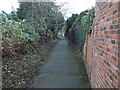
3
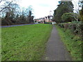
Footpath alongside Tilt Road, Stoke D'Abernon (1)
Marked on the OS 1:25000 map as a public footpath separately from the road.
Image: © Richard Vince
Taken: 14 Dec 2024
0.06 miles
4
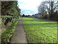
Footpath alongside Tilt Road, Stoke D'Abernon (2)
Marked on the OS 1:25000 map as a public footpath separately from the road.
Image: © Richard Vince
Taken: 14 Dec 2024
0.07 miles
5
Tilt Road, Cobham
The view north-east along Tilt Road. For the view north-west along the same road, see Image
Image: © Hugh Craddock
Taken: 26 Apr 2008
0.09 miles
7

Ash bridge
Ash bridge carries River Lane, a public bridleway (Esher 82), over the River Mole at Stoke d'Abernon. Until the 1990s, there was only a ford here, and the path could be followed only by horseriders or the more intrepid walkers.
Image: © Hugh Craddock
Taken: 26 Apr 2008
0.10 miles
8
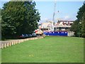
Tilt Road Cobham, with new housing under construction
looking north-west
Image: © Andrew Longton
Taken: 8 Sep 2005
0.10 miles
9

Mausoleum, Cobham Cemetery
In a locked off wedge at the edge of the cemetery is a remarkable mausoleum, with no names visible. Across the top is inscribed 'For where two or three are gathered together in my name there am I in the midst of them'. At this end of the compound is a nude statue seen in Image reaching towards this building.
Image: © Robin Webster
Taken: 21 Nov 2011
0.11 miles
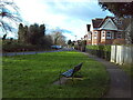
10
Footpath to D'Abernon Drive, Stoke D'Abernon
Signposted to the railway station, off Tilt Road.
Image: © Richard Vince
Taken: 14 Dec 2024
0.11 miles