IMAGES TAKEN NEAR TO
High Street, COBHAM, KT11 3DP
Introduction
This page details the photographs taken nearby to High Street, KT11 3DP by members of the Geograph project.
The Geograph project started in 2005 with the aim of publishing, organising and preserving representative images for every square kilometre of Great Britain, Ireland and the Isle of Man.

There are currently over 7.5m images from over14,400 individuals and you can help contribute to the project by visiting https://www.geograph.org.uk
Image Map
Images are licensed for reuse under creativecommons.org/licenses/by-sa/2.0
Notes
- Clicking on the map will re-center to the selected point.
- The higher the marker number, the further away the image location is from the centre of the postcode.
Image Listing (122 Images Found)
Images are licensed for reuse under creativecommons.org/licenses/by-sa/2.0
Image
Details
Distance
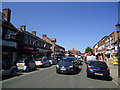
2

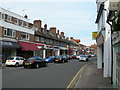
High Street
Few chain store outlets in the main shopping street of the exclusive Surrey town of Cobham.
Image: © Colin Smith
Taken: 6 May 2008
0.02 miles
3
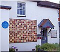
Fox & Hounds (demolished) : Cobham
This artwork is on a building named Fox House. The blue plaque commemorates the public house called the 'Fox and Hounds' which has been demolished.
Image: © Len Williams
Taken: 4 Aug 2014
0.03 miles
4
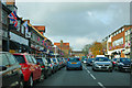
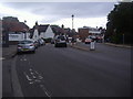
Cobham High Street
Bedecked with Union flags, but one or two are Royal British Legion flags, so at a guess they are responsible and the occasion was Remembrance Day.
Image: © Robin Webster
Taken: 12 Nov 2011
0.03 miles

7
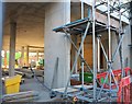
New shops and care home under construction in Cobham
A very nice modern row of shops has just been demolished to build replacement shops with a care home above. This was taken through a security gate with little room for a lens.
Image: © David Howard
Taken: 25 Sep 2018
0.05 miles
8
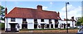
The Old Bear public house : Cobham
The (Old) Bear was built as farm house in the 15th or early 16th century and became a public house during the 18th century. The earliest recorded reference to the Bear is in a deed dated 1719 when Mary King of Cobham, widow, and John King her eldest son conveyed to Robert Patten of Ham, near Kingston, yeoman, 'All That freehold Messuage or Tenement or Inne situate and being in Coveham also Cobham aforesaid commonly called or known by the Signe of the Beare in or neare a certain street there called Church Street '.
Image: © Len Williams
Taken: 4 Aug 2014
0.05 miles
9
High Street, Cobham (1)
Near the junction of Church Street.
Image: © Danny P Robinson
Taken: 30 Sep 2007
0.05 miles
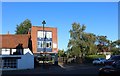
10
High Street Cobham
From the part where it becomes Mill Road on the bend of the river Mole.
Image: © David Howard
Taken: 18 Jul 2011
0.05 miles