IMAGES TAKEN NEAR TO
Hill View Place, COBHAM, KT11 2QA
Introduction
This page details the photographs taken nearby to Hill View Place, KT11 2QA by members of the Geograph project.
The Geograph project started in 2005 with the aim of publishing, organising and preserving representative images for every square kilometre of Great Britain, Ireland and the Isle of Man.

There are currently over 7.5m images from over14,400 individuals and you can help contribute to the project by visiting https://www.geograph.org.uk
Image Map
Images are licensed for reuse under creativecommons.org/licenses/by-sa/2.0
Notes
- Clicking on the map will re-center to the selected point.
- The higher the marker number, the further away the image location is from the centre of the postcode.
Image Listing (8 Images Found)
Images are licensed for reuse under creativecommons.org/licenses/by-sa/2.0
Image
Details
Distance
1
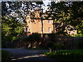
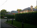
Knapp Hill, Little Heath
Large red brick house in a leafy and upmarket residential area of Cobham.
Image: © Colin Smith
Taken: 17 Oct 2010
0.09 miles
2
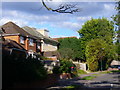
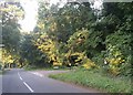
Links Green Way
Commuter land by Little Heath, on the southern edge of Cobham.
Image: © Colin Smith
Taken: 17 Oct 2010
0.10 miles
3
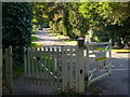
Eaton Park Road
Private road, with a footpath alongside it, in an exclusive residential area of Cobham.
Image: © Colin Smith
Taken: 17 Oct 2010
0.19 miles
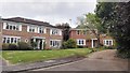
6
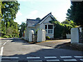
Small Lodge
At the corner of Miles Lane and Fairmile Park Road.
Image: © Robin Webster
Taken: 26 Aug 2012
0.24 miles
8
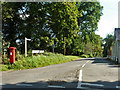
Fairmile Park Road
The beginning at the Miles Lane junction.
Image: © Robin Webster
Taken: 26 Aug 2012
0.25 miles