IMAGES TAKEN NEAR TO
Nightingale Close, COBHAM, KT11 2BP
Introduction
This page details the photographs taken nearby to Nightingale Close, KT11 2BP by members of the Geograph project.
The Geograph project started in 2005 with the aim of publishing, organising and preserving representative images for every square kilometre of Great Britain, Ireland and the Isle of Man.

There are currently over 7.5m images from over14,400 individuals and you can help contribute to the project by visiting https://www.geograph.org.uk
Image Map
Images are licensed for reuse under creativecommons.org/licenses/by-sa/2.0
Notes
- Clicking on the map will re-center to the selected point.
- The higher the marker number, the further away the image location is from the centre of the postcode.
Image Listing (25 Images Found)
Images are licensed for reuse under creativecommons.org/licenses/by-sa/2.0
Image
Details
Distance
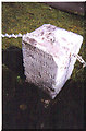
2
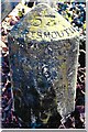
Old Milestone by A307 (was A3), just East of junction with Fairmile lane
The Milestone is located by the road. Parish of Fairmile (Elmsbridge District). Carved stone post, Guildford facets design, erected by the Kingston & Sheetbridge, 1st District turnpike trust in the 19th Century.
Inscription reads:-
Hyde Park Corner / 16 : : Cobham / ? : : Esher / 2 : : 53 / Portsmouth
Milestone Society National ID: SY_LP16
Image: © Derek Renn
Taken: 1 Jan 2023
0.04 miles
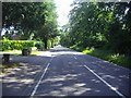
6
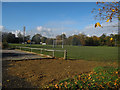
Cobham Rugby Club
Off Fairmile Lane, see http://www.cobhamrfc.com/
Image: © Hugh Venables
Taken: 6 Nov 2010
0.09 miles
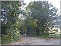
7
Old Milestone by the A307, Portsmouth Road, Cobham Parish
Carved stone post by the A307 (was A3), in parish of COBHAM (ELMBRIDGE District), Portsmouth Road, in garden of Ocho Rios, West of junction with Fairmile Lane, East of Fairmile Premier Inn (Fairmile Lodge), used as chain fence support, on North side of road. Erected by the Kingston & Sheetbridge, 1st District turnpike trust in the 19th century.
No longer visible on Streetview.
Inscription reads:- : from / LONDON :
Milestone Society National ID: SY_LP16.
Image: © C Woodward
Taken: 9 Aug 2005
0.12 miles
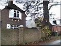
10
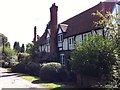
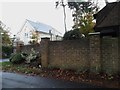
The Coach House
Large house fronting onto Fairmile Common, reached along the Lea off the Portsmouth Road.
Image: © Hugh Craddock
Taken: 5 Aug 2011
0.14 miles