IMAGES TAKEN NEAR TO
Pointers Road, COBHAM, KT11 1PQ
Introduction
This page details the photographs taken nearby to Pointers Road, KT11 1PQ by members of the Geograph project.
The Geograph project started in 2005 with the aim of publishing, organising and preserving representative images for every square kilometre of Great Britain, Ireland and the Isle of Man.

There are currently over 7.5m images from over14,400 individuals and you can help contribute to the project by visiting https://www.geograph.org.uk
Image Map
Images are licensed for reuse under creativecommons.org/licenses/by-sa/2.0
Notes
- Clicking on the map will re-center to the selected point.
- The higher the marker number, the further away the image location is from the centre of the postcode.
Image Listing (25 Images Found)
Images are licensed for reuse under creativecommons.org/licenses/by-sa/2.0
Image
Details
Distance
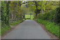
1
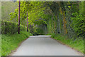
Pointers Road
Spring colours along this rural road near Cobham.
Image: © Alan Hunt
Taken: 3 May 2016
0.07 miles
2
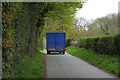
Farm trailer, Pointers Road
A tractor and trailer on Pointers Road, a rural road near Cobham.
Image: © Alan Hunt
Taken: 3 May 2016
0.07 miles
3
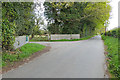
Pointers Road near Cobham
The entrance to the small hamlet around Poynters House. There appears to be two different spellings in play with Poynters Farm, Poynters House and Pointers Road, Pointers Green in the locale. Old OS maps indicate that Pointers was the original spelling with the names being changed to Poynters after 1930.
Image: © Alan Hunt
Taken: 3 May 2016
0.08 miles
4
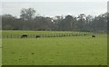
Poynters
Fields belonging to Poynters Stables; taken from TQ096585 looking south
Image: © Ben Gamble
Taken: 12 Apr 2005
0.08 miles
5
Pointers Road near Cobham
A rural road in the farmland to the southwest of Cobham.
Image: © Alan Hunt
Taken: 3 May 2016
0.13 miles
6
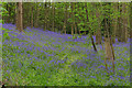
Bluebell Woods off Pointers Road
The bluebell woods next to The Lodge on Pointers Road. As ever the photograph doesn't do justice to the view.
Image: © Alan Hunt
Taken: 3 May 2016
0.13 miles
7

Pointers Road
This quiet lane (for traffic) is now a dead end. It has several select residences spaced along its length but it sits between stretches of the A3 and the M25.
Image: © Colin Smith
Taken: 23 Aug 2008
0.14 miles
8
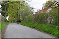
Pointers Road
Looking west along Pointers Road with the roof of Ty Bryn to the right.
Image: © Alan Hunt
Taken: 3 May 2016
0.14 miles
9
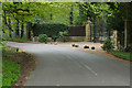
The Lodge gateway, Pointers Road
This fine gate used to be the entrance to Hatchford Park before the M25 cut a swathe across Surrey divorcing the gate and lodge from the house. Hatchford Park now has an entrance off Ockham Lane on the other side of the M25.
Image: © Alan Hunt
Taken: 3 May 2016
0.15 miles
10
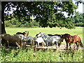
Summer's Arrived!
A hot August morning on Pointers Road, sheltering beneath a tree from the sunlight.
Image: © Colin Smith
Taken: 23 Aug 2008
0.17 miles