IMAGES TAKEN NEAR TO
Pointers Road, COBHAM, KT11 1PL
Introduction
This page details the photographs taken nearby to Pointers Road, KT11 1PL by members of the Geograph project.
The Geograph project started in 2005 with the aim of publishing, organising and preserving representative images for every square kilometre of Great Britain, Ireland and the Isle of Man.

There are currently over 7.5m images from over14,400 individuals and you can help contribute to the project by visiting https://www.geograph.org.uk
Image Map
Images are licensed for reuse under creativecommons.org/licenses/by-sa/2.0
Notes
- Clicking on the map will re-center to the selected point.
- The higher the marker number, the further away the image location is from the centre of the postcode.
Image Listing (28 Images Found)
Images are licensed for reuse under creativecommons.org/licenses/by-sa/2.0
Image
Details
Distance
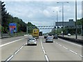
1
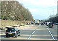
Cutting, M25
Heading anticlockwise through Ockham Common.
Image: © JThomas
Taken: 5 Mar 2012
0.08 miles
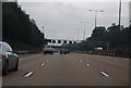
2
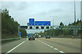
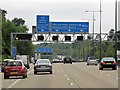
M25 junction 10
The dedicated lane for the A3 is just about to double.
Image: © Robin Webster
Taken: 9 Nov 2011
0.12 miles
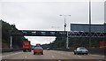
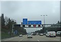
3
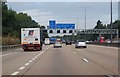
M25 clockwise approaching Junction 10
Image: © Julian P Guffogg
Taken: 7 Aug 2013
0.13 miles
6
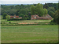
Chatley Farm
The view of Chatley Farm from the edge of Chatley Wood.
Image: © Alan Hunt
Taken: 3 Jun 2014
0.14 miles
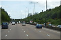
10
Junction 10
The view of the M25 approaching Junction 10.
Image: © Gordon Griffiths
Taken: 27 Dec 2019
0.15 miles