IMAGES TAKEN NEAR TO
Portsmouth Road, COBHAM, KT11 1DN
Introduction
This page details the photographs taken nearby to Portsmouth Road, KT11 1DN by members of the Geograph project.
The Geograph project started in 2005 with the aim of publishing, organising and preserving representative images for every square kilometre of Great Britain, Ireland and the Isle of Man.

There are currently over 7.5m images from over14,400 individuals and you can help contribute to the project by visiting https://www.geograph.org.uk
Image Map
Images are licensed for reuse under creativecommons.org/licenses/by-sa/2.0
Notes
- Clicking on the map will re-center to the selected point.
- The higher the marker number, the further away the image location is from the centre of the postcode.
Image Listing (24 Images Found)
Images are licensed for reuse under creativecommons.org/licenses/by-sa/2.0
Image
Details
Distance
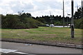
5
Old bridge sign on Portsmouth Road, Cobham
This is the same as the one here in Barnes http://www.geograph.org.uk/photo/4210199
Image: © David Howard
Taken: 19 Oct 2014
0.12 miles
6
Cobham : Painshill A245
At the roundabout at Painshill.
Image: © Lewis Clarke
Taken: 8 Aug 2015
0.12 miles
7
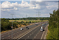
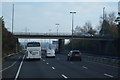
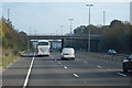
Esher Bypass
The A3 seen from the top deck of a Routemaster crossing on the A245.
Image: © Martin Addison
Taken: 17 Jul 2010
0.12 miles