IMAGES TAKEN NEAR TO
Ashburnham Park, ESHER, KT10 9TW
Introduction
This page details the photographs taken nearby to Ashburnham Park, KT10 9TW by members of the Geograph project.
The Geograph project started in 2005 with the aim of publishing, organising and preserving representative images for every square kilometre of Great Britain, Ireland and the Isle of Man.

There are currently over 7.5m images from over14,400 individuals and you can help contribute to the project by visiting https://www.geograph.org.uk
Image Map
Images are licensed for reuse under creativecommons.org/licenses/by-sa/2.0
Notes
- Clicking on the map will re-center to the selected point.
- The higher the marker number, the further away the image location is from the centre of the postcode.
Image Listing (52 Images Found)
Images are licensed for reuse under creativecommons.org/licenses/by-sa/2.0
Image
Details
Distance
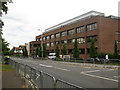
5
New Road, Esher
View south from junction with Carrick Gate, showing traffic-calming.
Image: © Alex McGregor
Taken: 5 Mar 2010
0.13 miles
6
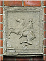
Stone plaque on a gatepost at Sandown Park Racecourse
Image: © Mike Quinn
Taken: 2 May 2018
0.13 miles
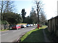
7
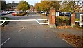
Car park entrance, Sandown Park Racecourse
Image: © N Chadwick
Taken: 2 Nov 2017
0.14 miles
8
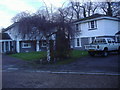
St Andrew's House
Seen during the road closure for the Olympic cycling time trial.
Image: © don cload
Taken: 1 Aug 2012
0.14 miles
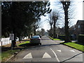
9
New Road, Esher
View facing south down New Road,from the junction with Portsmouth Road
Image: © Alex McGregor
Taken: 5 Mar 2010
0.14 miles