IMAGES TAKEN NEAR TO
Littlemead, ESHER, KT10 9PE
Introduction
This page details the photographs taken nearby to Littlemead, KT10 9PE by members of the Geograph project.
The Geograph project started in 2005 with the aim of publishing, organising and preserving representative images for every square kilometre of Great Britain, Ireland and the Isle of Man.

There are currently over 7.5m images from over14,400 individuals and you can help contribute to the project by visiting https://www.geograph.org.uk
Image Map
Images are licensed for reuse under creativecommons.org/licenses/by-sa/2.0
Notes
- Clicking on the map will re-center to the selected point.
- The higher the marker number, the further away the image location is from the centre of the postcode.
Image Listing (15 Images Found)
Images are licensed for reuse under creativecommons.org/licenses/by-sa/2.0
Image
Details
Distance
1
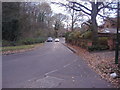
Littleworth Road, Esher
At junction of Littleworth Lane
Image: © David Howard
Taken: 29 Nov 2010
0.10 miles
2
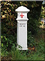
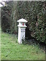
Coal tax boundary post no.106, Littleworth Road
The location of this post is shown in Image (photographed by Graham Howard).
I am grateful to Nigel Cox (Ticket Moderator) and Colin Early for the information that this is a Coal Tax Post. Such posts were erected under the Coal and Wine Duties (Continuation) Act of 1861 to mark the points at which duty had to be paid on coal being transported to London. The boundary was set at that of the Metropolitan Police District, and the resulting revenue was used by the Corporation of the City of London to fund public works.There are over 200 of these posts located around London, 23 of which are known to have survived within Elmbridge Borough. Please see Image, http://www.elmbridge.gov.uk/Tourism/coalwine.htm and http://www.pmsa.org.uk/pmsa-database/2934/ .
Image: © Mike Quinn
Taken: 1 Oct 2008
0.11 miles
3
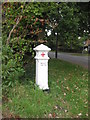
Coal Tax marker post
Coal Tax marker post at the junction of Littleworth Road and New Road
Image: © Graham Howard
Taken: 14 Oct 2010
0.11 miles
4
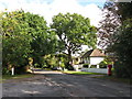
Littleworth Road / New Road (2)
Image: © Mike Quinn
Taken: 1 Oct 2008
0.11 miles
5
Coal Tax marker post
Coal Tax marker post on Littleworth Lane
Image: © Graham Howard
Taken: 14 Oct 2010
0.12 miles
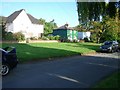
6
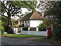
Houses in Littleworth Road
Shows the location of Image
Image: © Mike Quinn
Taken: 1 Oct 2008
0.12 miles
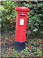
7
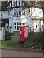
Esher: postbox № KT10 197, Littleworth Road
One of few pillar boxes to be cast during the short reign of Edward VIII - there are 80 or so still in use. This one faces the New Road turning and is emptied finally at 5:30pm on weekdays and at 11:45am on Saturdays.
See Image for a close-up of the cipher.
Image: © Chris Downer
Taken: 18 Jan 2014
0.12 miles
8
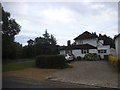
House on the corner of New Road and Littleworth Road
Image: © David Howard
Taken: 28 May 2017
0.12 miles
10
Edward VIII postbox, Littleworth Road / New Road
Image: © Mike Quinn
Taken: 1 Oct 2008
0.13 miles