IMAGES TAKEN NEAR TO
Old Church Path, ESHER, KT10 9NS
Introduction
This page details the photographs taken nearby to Old Church Path, KT10 9NS by members of the Geograph project.
The Geograph project started in 2005 with the aim of publishing, organising and preserving representative images for every square kilometre of Great Britain, Ireland and the Isle of Man.

There are currently over 7.5m images from over14,400 individuals and you can help contribute to the project by visiting https://www.geograph.org.uk
Image Map
Images are licensed for reuse under creativecommons.org/licenses/by-sa/2.0
Notes
- Clicking on the map will re-center to the selected point.
- The higher the marker number, the further away the image location is from the centre of the postcode.
Image Listing (217 Images Found)
Images are licensed for reuse under creativecommons.org/licenses/by-sa/2.0
Image
Details
Distance
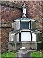
3
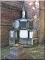
St George's Church, Esher - tombstone
Tombstone of Jacob Bright
Image: © Graham Howard
Taken: 11 Oct 2010
0.03 miles
4
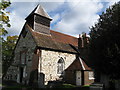
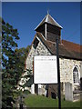
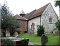
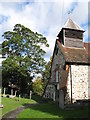
St. George's Church
Esher's oldest public building; most of the structure is 16th C. See Image
Image: © Mike Quinn
Taken: 1 Oct 2008
0.03 miles
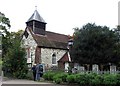

7

St George, Esher, Surrey - Toadstools in churchyard
Image: © John Salmon
Taken: 14 Oct 2005
0.03 miles
8

St George, Esher, Surrey - Toadstools in churchyard
Image: © John Salmon
Taken: 14 Oct 2005
0.03 miles