IMAGES TAKEN NEAR TO
Courtlands Avenue, ESHER, KT10 9HZ
Introduction
This page details the photographs taken nearby to Courtlands Avenue, KT10 9HZ by members of the Geograph project.
The Geograph project started in 2005 with the aim of publishing, organising and preserving representative images for every square kilometre of Great Britain, Ireland and the Isle of Man.

There are currently over 7.5m images from over14,400 individuals and you can help contribute to the project by visiting https://www.geograph.org.uk
Image Map
Images are licensed for reuse under creativecommons.org/licenses/by-sa/2.0
Notes
- Clicking on the map will re-center to the selected point.
- The higher the marker number, the further away the image location is from the centre of the postcode.
Image Listing (54 Images Found)
Images are licensed for reuse under creativecommons.org/licenses/by-sa/2.0
Image
Details
Distance
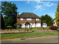
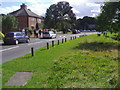
2
Original Houses in Courtlands Avenue in West End
Many of the houses in Esher have been modified, extended and rebuilt. In a few years the original houses will be in the minority.
Image: © James Emmans
Taken: 7 Aug 2016
0.04 miles
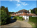
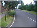
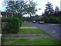
3

Hawkshill Way
Looking west along the road from close to its junction with the A307 Portsmouth Rd.
Image: © Nigel Mykura
Taken: 21 Jul 2013
0.08 miles
4
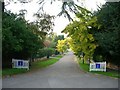
Courtlands Avenue
looking north-west from Stony Hill
Image: © Andrew Longton
Taken: 11 Oct 2005
0.10 miles
9
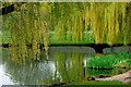
A fall of willow
Looking across Westend pond
Image: © Alan Varndell
Taken: 21 Apr 2006
0.13 miles
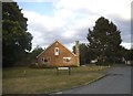
10
Village Hall, West End, Esher
The well renovated village hall at West End.
Image: © Len Williams
Taken: 9 Jul 2013
0.13 miles