IMAGES TAKEN NEAR TO
Home Farm Close, ESHER, KT10 9HA
Introduction
This page details the photographs taken nearby to Home Farm Close, KT10 9HA by members of the Geograph project.
The Geograph project started in 2005 with the aim of publishing, organising and preserving representative images for every square kilometre of Great Britain, Ireland and the Isle of Man.

There are currently over 7.5m images from over14,400 individuals and you can help contribute to the project by visiting https://www.geograph.org.uk
Image Map
Images are licensed for reuse under creativecommons.org/licenses/by-sa/2.0
Notes
- Clicking on the map will re-center to the selected point.
- The higher the marker number, the further away the image location is from the centre of the postcode.
Image Listing (30 Images Found)
Images are licensed for reuse under creativecommons.org/licenses/by-sa/2.0
Image
Details
Distance
1
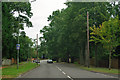
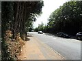
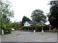
A244, Esher
Heading north towards the town centre.
Image: © Robin Webster
Taken: 24 Aug 2012
0.07 miles
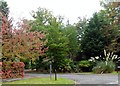
7
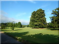
Clare Hill Golf Club
Small Golf Course quite close to Esher town centre.
Image: © James Emmans
Taken: 7 Aug 2016
0.16 miles
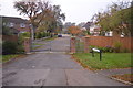
10
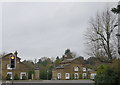
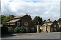
Lodges to Claremont House
These two lodges are on Copsem Lane, the A244, on either side of the junction with Claremont Park Lane. Both the lodges are now private houses with additional accommodation built on the back.
Image: © Nigel Mykura
Taken: 3 Dec 2015
0.18 miles