IMAGES TAKEN NEAR TO
Hare Lane, ESHER, KT10 9BX
Introduction
This page details the photographs taken nearby to Hare Lane, KT10 9BX by members of the Geograph project.
The Geograph project started in 2005 with the aim of publishing, organising and preserving representative images for every square kilometre of Great Britain, Ireland and the Isle of Man.

There are currently over 7.5m images from over14,400 individuals and you can help contribute to the project by visiting https://www.geograph.org.uk
Image Map
Images are licensed for reuse under creativecommons.org/licenses/by-sa/2.0
Notes
- Clicking on the map will re-center to the selected point.
- The higher the marker number, the further away the image location is from the centre of the postcode.
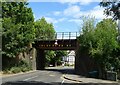
Image Listing (53 Images Found)
Images are licensed for reuse under creativecommons.org/licenses/by-sa/2.0
Image
Details
Distance
4
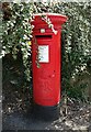
George V postbox on Hare Lane, Claygate
Postbox No. KT10 184.
Image: © JThomas
Taken: 25 Jul 2022
0.06 miles
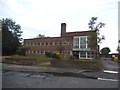
7
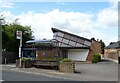
First Church of Christ, Scientist, Claygate
Image: © JThomas
Taken: 25 Jul 2022
0.07 miles

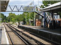
10
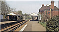
Claygate station, 1984
View northward, towards Hampton Court Junction, Surbiton and Waterloo: ex-LSWR 'New Guildford Line', Waterloo - Surbiton - Cobham - Guildford.
Image: © Ben Brooksbank
Taken: 29 Apr 1984
0.08 miles