IMAGES TAKEN NEAR TO
Hampton Court Way, ESHER, KT10 9AN
Introduction
This page details the photographs taken nearby to Hampton Court Way, KT10 9AN by members of the Geograph project.
The Geograph project started in 2005 with the aim of publishing, organising and preserving representative images for every square kilometre of Great Britain, Ireland and the Isle of Man.

There are currently over 7.5m images from over14,400 individuals and you can help contribute to the project by visiting https://www.geograph.org.uk
Image Map
Images are licensed for reuse under creativecommons.org/licenses/by-sa/2.0
Notes
- Clicking on the map will re-center to the selected point.
- The higher the marker number, the further away the image location is from the centre of the postcode.
Image Listing (83 Images Found)
Images are licensed for reuse under creativecommons.org/licenses/by-sa/2.0
Image
Details
Distance
1
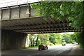
A309 passing under South Western Main Line
The main road is approaching the Scilly Isles junction with the A307. On the left beyond the bridge is Ditton Common.
Image: © Derek Harper
Taken: 29 May 2016
0.02 miles
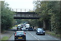
3
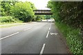
Bridge over A309
The main road approaches the bridge shown in Image Just before it, footpath Esher NCP 12b crosses the road. On the left is the southern edge of Weston Green.
Image: © Derek Harper
Taken: 29 May 2016
0.02 miles
4
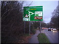
Scilly Isles sign
Hampton Court Way, Thames Ditton, Surrey
Image: © David Howard
Taken: 30 Nov 2008
0.02 miles

6
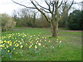
Daffodils on Weston Green
This is the far western part of Weston Green close to Hampton Court Way. The main line railway between Esher and Surbiton runs on an embankment just beyond the trees ahead.
Image: © Marathon
Taken: 19 Mar 2014
0.04 miles
7
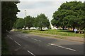
Weston Green
In the foreground is the A309. Beyond the green and its trees are cottages along the road also called Weston Green.
Image: © Derek Harper
Taken: 29 May 2016
0.05 miles
8
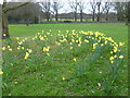
Daffodils on Weston Green
This is the far western part of Weston Green looking across Hampton Court Way to Ditton Common. Hampton Court Way is so busy it is necessary to wait quite some time to obtain a photograph without cars.
Image: © Marathon
Taken: 19 Mar 2014
0.05 miles
9
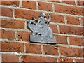
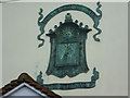
Fire insurance mark on the wall of Admiral Manor
Admiral Manor dates from circa 1750 according to the plaque on its wall and nearby is its fire insurance mark. Fire insurance marks were placed on the front of the insured building as a guide to the insurance company's fire brigade. For most of the 18th century, each insurance company maintained its own fire brigade, which extinguished fires in those buildings insured by the company. However, long after proper fire brigades came into being fire insurance marks were left on houses as here. A selection of images of fire insurance marks can be seen here - https://www.google.co.uk/search?q=fire+marks&espv=2&es_sm=93&tbm=isch&tbo=u&source=univ&sa=X&ei=XAQqU8WLLoqi0QXYwIGQCQ&ved=0CCwQsAQ&biw=1600&bih=777
Image: © Marathon
Taken: 19 Mar 2014
0.06 miles
10
Sundial at Weston Green
This very fine sundial is on the wall of a house above the porch overlooking Weston Green. The road it is on is also called Weston Green. The date in Roman numerals says 1828.
Image: © Marathon
Taken: 19 Mar 2014
0.07 miles