IMAGES TAKEN NEAR TO
Portsmouth Road, ESHER, KT10 9AB
Introduction
This page details the photographs taken nearby to Portsmouth Road, KT10 9AB by members of the Geograph project.
The Geograph project started in 2005 with the aim of publishing, organising and preserving representative images for every square kilometre of Great Britain, Ireland and the Isle of Man.

There are currently over 7.5m images from over14,400 individuals and you can help contribute to the project by visiting https://www.geograph.org.uk
Image Map
Images are licensed for reuse under creativecommons.org/licenses/by-sa/2.0
Notes
- Clicking on the map will re-center to the selected point.
- The higher the marker number, the further away the image location is from the centre of the postcode.
Image Listing (58 Images Found)
Images are licensed for reuse under creativecommons.org/licenses/by-sa/2.0
Image
Details
Distance
2
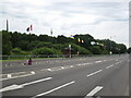
Olympic flags by Littleworth Common
The road is closed and the flags are out in preparation for the Olympic cycling time trial.
Image: © don cload
Taken: 1 Aug 2012
0.05 miles
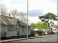
3
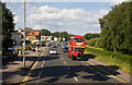
Portsmouth Road
The A307 seen where it passes Littleworth Common. In the distance are the lights at the junction with Station Road. Approaching, on its way back to the London Bus Preservation Trust at Cobham, is RTL139, a Leyland example of the famous RT marque. Although a 'red' vehicle, she has been taking part in the Green Line 80th Anniversary celebrations. This photo was taken from the top deck of RCL2260, a long Routemaster coach on a return run to Victoria Embankment, London.
Image: © Martin Addison
Taken: 17 Jul 2010
0.05 miles
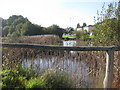
5
Portsmouth Road / Littleworth Common Road
Shows the location of Image (lower left).
Image: © Mike Quinn
Taken: 2 May 2018
0.07 miles
6
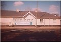
Old Toll House by the A307, Portsmouth Road, Sandown Park
Toll House by the A307 (was A3), in parish of Esher (Elmbridge District), The Toll House, Portsmouth Road, Sandown Park, KT10 9AA. A Coal Tax post stands in front of the Toll House.
Surveyed
Milestone Society National ID: SY.ESH
Image: © Milestone Society
Taken: Unknown
0.07 miles
8
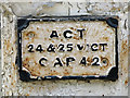
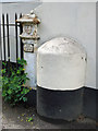
Coal tax boundary post no.104, Portsmouth Road, Esher (detail)
See Image
This post is one of 14 with extant correction plates (13 of which are of the same type as this one). For further info, see Image
Image: © Mike Quinn
Taken: 2 May 2018
0.08 miles
9
Coal tax boundary post no.104, Portsmouth Road, Esher (2)
See Image
Image: © Mike Quinn
Taken: 2 May 2018
0.08 miles
10
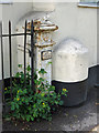
Coal tax boundary post no.104, Portsmouth Road, Esher
The location of this coal tax post is shown in Image
The post is Grade II listed https://historicengland.org.uk/listing/the-list/list-entry/1030136 .
There are over 200 coal tax posts located around London, most of which are 3 ft high white-painted bollards http://www.geograph.org.uk/search.php?i=86542993&page=1 . The posts were erected under the Coal and Wine Duties (Continuation) Act of 1861 to mark the points at which duty had to be paid on coal being transported to London. The boundary was set at that of the Metropolitan Police District, and the resulting revenue was used by the Corporation of the City of London to fund public works. For further info see http://www.coaldutyposts.org.uk/cityposts.html .
Image: © Mike Quinn
Taken: 2 May 2018
0.08 miles