IMAGES TAKEN NEAR TO
Wolsey Road, ESHER, KT10 8NT
Introduction
This page details the photographs taken nearby to Wolsey Road, KT10 8NT by members of the Geograph project.
The Geograph project started in 2005 with the aim of publishing, organising and preserving representative images for every square kilometre of Great Britain, Ireland and the Isle of Man.

There are currently over 7.5m images from over14,400 individuals and you can help contribute to the project by visiting https://www.geograph.org.uk
Image Map
Images are licensed for reuse under creativecommons.org/licenses/by-sa/2.0
Notes
- Clicking on the map will re-center to the selected point.
- The higher the marker number, the further away the image location is from the centre of the postcode.
Image Listing (212 Images Found)
Images are licensed for reuse under creativecommons.org/licenses/by-sa/2.0
Image
Details
Distance
1
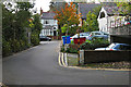
Wolsey Road, Esher
The double bend in Wolsey Road in Esher.
Image: © Alan Hunt
Taken: 8 Oct 2015
0.04 miles
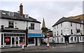
2
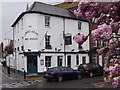
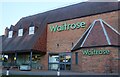
Albert Arms, Esher
Corner pub where High Street and Park Road meet in central Esher.
http://en.wikipedia.org/wiki/Esher
Image: © Colin Smith
Taken: 22 Apr 2012
0.07 miles
4
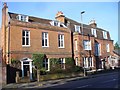
Esher - High Street
Grand and substantial brick buildings at the SW end of the village centre, on the former main road London-Portsmouth.
Image: © Colin Smith
Taken: 14 Jan 2015
0.07 miles