IMAGES TAKEN NEAR TO
West End Lane, ESHER, KT10 8LE
Introduction
This page details the photographs taken nearby to West End Lane, KT10 8LE by members of the Geograph project.
The Geograph project started in 2005 with the aim of publishing, organising and preserving representative images for every square kilometre of Great Britain, Ireland and the Isle of Man.

There are currently over 7.5m images from over14,400 individuals and you can help contribute to the project by visiting https://www.geograph.org.uk
Image Map
Images are licensed for reuse under creativecommons.org/licenses/by-sa/2.0
Notes
- Clicking on the map will re-center to the selected point.
- The higher the marker number, the further away the image location is from the centre of the postcode.
Image Listing (48 Images Found)
Images are licensed for reuse under creativecommons.org/licenses/by-sa/2.0
Image
Details
Distance
1
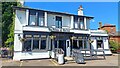
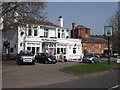
Prince of Wales, West End
Chef & Brewer pub facing the green at West End.
Image: © Mark Percy
Taken: 14 Jun 2022
0.06 miles
2
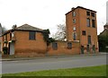
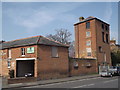
Esher: The Old Brewery, West End
These buildings, on West End Lane, now seem to be part of the adjacent Prince of Wales public house, but are shown as "The Old Brewery" on the latest large scale Ordnance Survey mapping.
Image: © Nigel Cox
Taken: 27 Feb 2016
0.06 miles
3
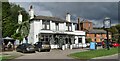
West End - Prince of Wales
Village pub facing the green and pond at West End.
Image: © Colin Smith
Taken: 15 Oct 2020
0.06 miles
4
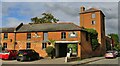
West End - Chef & Brewer
Red brick extension to the Prince of Wales pub, perhaps an old brewery.
Image: © Colin Smith
Taken: 15 Oct 2020
0.06 miles
5
West End, Prince of Wales
Distinctive red brick outbuildings behind the popular pub which is now part of the Chef & Brewer chain.
http://en.wikipedia.org/wiki/West_End,_Esher
Image: © Colin Smith
Taken: 23 Mar 2012
0.06 miles
6
The Prince of Wales, West End
Popular historic inn facing a corner of the village green at West End, Esher.
http://en.wikipedia.org/wiki/West_End,_Esher
Image: © Colin Smith
Taken: 23 Mar 2012
0.06 miles
7
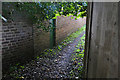
Footpath to West End Lane
The footpath from Portsmouth Road across the golf course ends winding between walls and fences as it approaches West End Lane.
Image: © Alan Hunt
Taken: 8 Oct 2015
0.07 miles
8
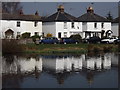
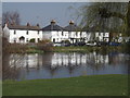
West End Reflections
Cottages on Winterdown Road reflected on the still waters of the large pond on the green.
http://en.wikipedia.org/wiki/West_End,_Esher
Image: © Colin Smith
Taken: 23 Mar 2012
0.08 miles
9
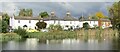
Winterdown Road
Whitewashed cottages reflected in the large pond at West End, Esher.
http://en.wikipedia.org/wiki/West_End,_Esher
Image: © Colin Smith
Taken: 23 Mar 2012
0.08 miles
10
Esher - West End
Cottages facing a large green with a pond next to West End Common.
Image: © Colin Smith
Taken: 15 Oct 2020
0.09 miles