IMAGES TAKEN NEAR TO
Elm Tree Avenue, ESHER, KT10 8JG
Introduction
This page details the photographs taken nearby to Elm Tree Avenue, KT10 8JG by members of the Geograph project.
The Geograph project started in 2005 with the aim of publishing, organising and preserving representative images for every square kilometre of Great Britain, Ireland and the Isle of Man.

There are currently over 7.5m images from over14,400 individuals and you can help contribute to the project by visiting https://www.geograph.org.uk
Image Map
Images are licensed for reuse under creativecommons.org/licenses/by-sa/2.0
Notes
- Clicking on the map will re-center to the selected point.
- The higher the marker number, the further away the image location is from the centre of the postcode.
Image Listing (43 Images Found)
Images are licensed for reuse under creativecommons.org/licenses/by-sa/2.0
Image
Details
Distance
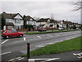
4
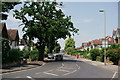
Thames Ditton
Looking north, along Ember Lane.
Image: © Peter Trimming
Taken: 6 Jul 2018
0.06 miles
5

Elmtree Avenue Junction with Hampton Court Way
Image: © James Emmans
Taken: 27 Jul 2016
0.07 miles
7
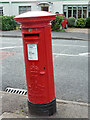
Postbox KT10 173
An Edward VII box, not very vertical.
Image: © Robin Webster
Taken: 26 Aug 2012
0.08 miles
8
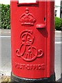
Edward VII postbox, Ember Lane / Elm Tree Avenue - royal cipher
See Image
Image: © Mike Quinn
Taken: 6 Jun 2018
0.08 miles
9
Edward VII postbox, Ember Lane / Elm Tree Avenue
Image: © Mike Quinn
Taken: 6 Jun 2018
0.08 miles
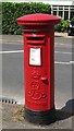
10
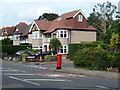
Postbox on corner of Elm Tree Avenue
Being right on the corner and rather vulnerable may be the reason it is far from vertical. It is an Edward VII box, number KT10 173.
Image: © Robin Webster
Taken: 26 Aug 2012
0.08 miles