IMAGES TAKEN NEAR TO
Woodend, ESHER, KT10 8DA
Introduction
This page details the photographs taken nearby to Woodend, KT10 8DA by members of the Geograph project.
The Geograph project started in 2005 with the aim of publishing, organising and preserving representative images for every square kilometre of Great Britain, Ireland and the Isle of Man.

There are currently over 7.5m images from over14,400 individuals and you can help contribute to the project by visiting https://www.geograph.org.uk
Image Map
Images are licensed for reuse under creativecommons.org/licenses/by-sa/2.0
Notes
- Clicking on the map will re-center to the selected point.
- The higher the marker number, the further away the image location is from the centre of the postcode.
Image Listing (36 Images Found)
Images are licensed for reuse under creativecommons.org/licenses/by-sa/2.0
Image
Details
Distance
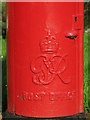
1
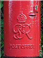
George VI postbox, Lower Green Road / Woodend - royal cipher
See Image
Image: © Mike Quinn
Taken: 2 May 2018
0.04 miles
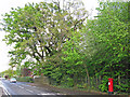
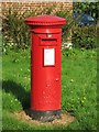
2
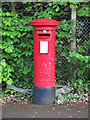
George VI postbox, Lower Green Road / Woodend
Image: © Mike Quinn
Taken: 2 May 2018
0.04 miles
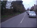
3
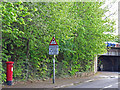
Lower Green Road and railway bridge
Shows the location of Image
Image: © Mike Quinn
Taken: 2 May 2018
0.05 miles
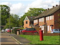
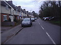
5
Lower Green Road / Woodend
Shows the location of Image
Image: © Mike Quinn
Taken: 2 May 2018
0.05 miles
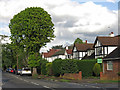
6
Lower Green, Esher
Sandown Park racecourse is on the left behind the trees
Image: © David Howard
Taken: 21 Mar 2011
0.10 miles
8
George VI postbox, Douglas Road / Blair Avenue - royal cipher
See Image
Image: © Mike Quinn
Taken: 2 May 2018
0.15 miles
9
George VI postbox, Douglas Road / Blair Avenue
Image: © Mike Quinn
Taken: 2 May 2018
0.15 miles