IMAGES TAKEN NEAR TO
Mountview Road, ESHER, KT10 0UD
Introduction
This page details the photographs taken nearby to Mountview Road, KT10 0UD by members of the Geograph project.
The Geograph project started in 2005 with the aim of publishing, organising and preserving representative images for every square kilometre of Great Britain, Ireland and the Isle of Man.

There are currently over 7.5m images from over14,400 individuals and you can help contribute to the project by visiting https://www.geograph.org.uk
Image Map
Images are licensed for reuse under creativecommons.org/licenses/by-sa/2.0
Notes
- Clicking on the map will re-center to the selected point.
- The higher the marker number, the further away the image location is from the centre of the postcode.
Image Listing (12 Images Found)
Images are licensed for reuse under creativecommons.org/licenses/by-sa/2.0
Image
Details
Distance
1
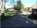
Barwell Farm
Just in the south east corner of the square.
Image: © Roger Miller
Taken: 29 Aug 2005
0.12 miles
2
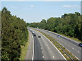
A3 towards London
The Greater London boundary with Surrey runs along the right hand side of the road, with Surrey on the left.
Image: © Robin Webster
Taken: 3 Sep 2012
0.17 miles
3
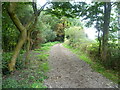
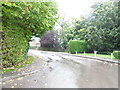
Bridleway through The Grapsome
The Grapsome is a small copse immediately to the west of the Esher By-pass (A3). The Grapsome is believed to be the site of a medieval manor, probably dating from before the Norman Conquest. The name may be of Old English origin, signifying the nick-name of the owner. In medieval times it was called 'Graplingeham', then over the centuries this altered to 'Grapham', then 'Grapson' and finally to 'The Grapsome'. On the First Edition Ordnance Survey Map of 1865, The Grapsome is clearly marked as deciduous woodland, but the present woods are a small fraction of their former size, the most recent reduction being in 1974/5 by the construction of the Esher By-pass through the eastern half.
A bridleway from Chessington passes under the A3 and then through the middle of The Grapsome on its way to Claygate. This view looks towards the latter.
Image: © Marathon
Taken: 25 Sep 2013
0.19 miles
4
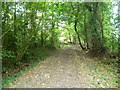
Bridleway through The Grapsome
The Grapsome is a small copse immediately to the west of the Esher By-pass (A3). The Grapsome is believed to be the site of a medieval manor, probably dating from before the Norman Conquest. The name may be of Old English origin, signifying the nick-name of the owner. In medieval times it was called 'Graplingeham', then over the centuries this altered to 'Grapham', then 'Grapson' and finally to 'The Grapsome'. On the First Edition Ordnance Survey Map of 1865, The Grapsome is clearly marked as deciduous woodland, but the present woods are a small fraction of their former size, the most recent reduction being in 1974/5 by the construction of the Esher By-pass through the eastern half.
A bridleway from Chessington passes under the A3 and then through the middle of The Grapsome on its way to Claygate. This view looks towards the latter.
Image: © Marathon
Taken: 25 Sep 2013
0.21 miles
5
Ruxley Ridge, Claygate
Not a good day for taking photos as you can see
Image: © David Howard
Taken: 21 Oct 2012
0.21 miles
6
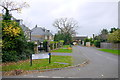
Trystings Close Claygate
This road consists mainly of detached modern houses. Last year 2015, two houses sold in this road for between £1.2M and £1.5M
Image: © Nigel Mykura
Taken: 3 Dec 2015
0.22 miles
7
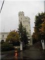
Ruxley Tower, Claygate
Part of a small stately home seen on the left.
Image: © David Howard
Taken: 21 Oct 2012
0.22 miles
8
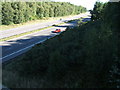
A3(T) from the bridleway bridge near Barwell Farm
Looking northeast.
Image: © Roger Miller
Taken: 29 Aug 2005
0.23 miles
9
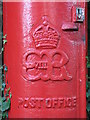
Edward VIII postbox, Ruxley Ridge/Stevens Lane - royal cipher
See Image
Image: © Mike Quinn
Taken: 1 Oct 2008
0.24 miles
10
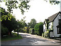
Ruxley Ridge / Stevens Lane
Image: © Mike Quinn
Taken: 1 Oct 2008
0.24 miles