IMAGES TAKEN NEAR TO
Trystings Close, ESHER, KT10 0TF
Introduction
This page details the photographs taken nearby to Trystings Close, KT10 0TF by members of the Geograph project.
The Geograph project started in 2005 with the aim of publishing, organising and preserving representative images for every square kilometre of Great Britain, Ireland and the Isle of Man.

There are currently over 7.5m images from over14,400 individuals and you can help contribute to the project by visiting https://www.geograph.org.uk
Image Map
Images are licensed for reuse under creativecommons.org/licenses/by-sa/2.0
Notes
- Clicking on the map will re-center to the selected point.
- The higher the marker number, the further away the image location is from the centre of the postcode.
Image Listing (6 Images Found)
Images are licensed for reuse under creativecommons.org/licenses/by-sa/2.0
Image
Details
Distance
1
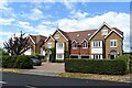
Trystings Close Claygate
This road consists mainly of detached modern houses. Last year 2015, two houses sold in this road for between £1.2M and £1.5M
Image: © Nigel Mykura
Taken: 3 Dec 2015
0.08 miles
4
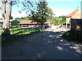
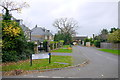
Barwell Farm
Just in the south east corner of the square.
Image: © Roger Miller
Taken: 29 Aug 2005
0.17 miles
5
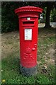
George V postbox on Red Lane, Claygate
Postbox No. KT10 179.
Image: © JThomas
Taken: 25 Jul 2022
0.23 miles