IMAGES TAKEN NEAR TO
Station Way, ESHER, KT10 0QS
Introduction
This page details the photographs taken nearby to Station Way, KT10 0QS by members of the Geograph project.
The Geograph project started in 2005 with the aim of publishing, organising and preserving representative images for every square kilometre of Great Britain, Ireland and the Isle of Man.

There are currently over 7.5m images from over14,400 individuals and you can help contribute to the project by visiting https://www.geograph.org.uk
Image Map
Images are licensed for reuse under creativecommons.org/licenses/by-sa/2.0
Notes
- Clicking on the map will re-center to the selected point.
- The higher the marker number, the further away the image location is from the centre of the postcode.
Image Listing (47 Images Found)
Images are licensed for reuse under creativecommons.org/licenses/by-sa/2.0
Image
Details
Distance
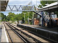
5
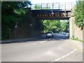
Railway bridge over Hare Lane, Claygate
Looking west.
Image: © Andrew Longton
Taken: 8 Sep 2005
0.06 miles
6
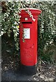
George V postbox on Hare Lane, Claygate
Postbox No. KT10 184.
Image: © JThomas
Taken: 25 Jul 2022
0.06 miles
7
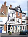
Barclays Bank, Claygate
Imposing building at the west end of The Parade, Claygate's main shopping street.
Image: © Colin Smith
Taken: 14 Mar 2009
0.06 miles
9
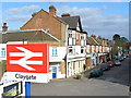
Claygate
Seen from the railway station footbridge, looking along The Parade - Claygate's main shopping street.
Image: © Colin Smith
Taken: 14 Mar 2009
0.07 miles
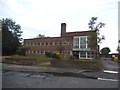
10
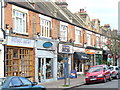
The Parade
Attractive shopping street in the heart of the commuters' town of Claygate.
Image: © Colin Smith
Taken: 14 Mar 2009
0.07 miles