IMAGES TAKEN NEAR TO
Firs Close, ESHER, KT10 0NW
Introduction
This page details the photographs taken nearby to Firs Close, KT10 0NW by members of the Geograph project.
The Geograph project started in 2005 with the aim of publishing, organising and preserving representative images for every square kilometre of Great Britain, Ireland and the Isle of Man.

There are currently over 7.5m images from over14,400 individuals and you can help contribute to the project by visiting https://www.geograph.org.uk
Image Map
Images are licensed for reuse under creativecommons.org/licenses/by-sa/2.0
Notes
- Clicking on the map will re-center to the selected point.
- The higher the marker number, the further away the image location is from the centre of the postcode.
Image Listing (96 Images Found)
Images are licensed for reuse under creativecommons.org/licenses/by-sa/2.0
Image
Details
Distance
5
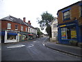
Road junction in Claygate
You can only get to Chessington or Esher from Claygate. There are no roads south to cross the A3.
Image: © David Howard
Taken: 28 May 2017
0.13 miles
6
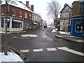
Claygate High Street
High Street in Claygate Surrey taken on a snow day.
Image: © Claygate Surrey
Taken: 20 Jan 2013
0.13 miles
8
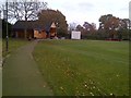
Claygate Recreation Ground
New Clubhouse at the Claygate rec 2012
Image: © Claygate Surrey
Taken: 7 Nov 2012
0.15 miles
9
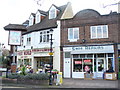
Flowers and Shoes
Village sign, flower shop and shoe repair shop on The Parade, Claygate.
Image: © Colin Smith
Taken: 14 Mar 2009
0.15 miles
10
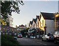
By the Green, Claygate
Well-served by restaurants - and the 'Hare and Hounds'.
Image: © Stefan Czapski
Taken: 4 Nov 2013
0.15 miles