IMAGES TAKEN NEAR TO
Foley Road, ESHER, KT10 0NA
Introduction
This page details the photographs taken nearby to Foley Road, KT10 0NA by members of the Geograph project.
The Geograph project started in 2005 with the aim of publishing, organising and preserving representative images for every square kilometre of Great Britain, Ireland and the Isle of Man.

There are currently over 7.5m images from over14,400 individuals and you can help contribute to the project by visiting https://www.geograph.org.uk
Image Map
Images are licensed for reuse under creativecommons.org/licenses/by-sa/2.0
Notes
- Clicking on the map will re-center to the selected point.
- The higher the marker number, the further away the image location is from the centre of the postcode.
Image Listing (43 Images Found)
Images are licensed for reuse under creativecommons.org/licenses/by-sa/2.0
Image
Details
Distance
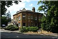
5
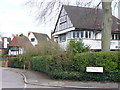
Claremont Road
Attractive mock-Tudor houses at the Beaconsfield Road corner in the dormitory town of Claygate.
Image: © Colin Smith
Taken: 14 Mar 2009
0.14 miles
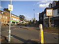
7
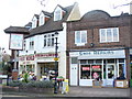
Flowers and Shoes
Village sign, flower shop and shoe repair shop on The Parade, Claygate.
Image: © Colin Smith
Taken: 14 Mar 2009
0.16 miles
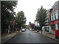
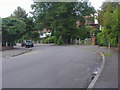
8
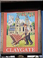
Claygate village sign
At the eastern end of Image
Image: © Mike Quinn
Taken: 1 Oct 2008
0.17 miles