IMAGES TAKEN NEAR TO
Hare Lane, ESHER, KT10 0LZ
Introduction
This page details the photographs taken nearby to Hare Lane, KT10 0LZ by members of the Geograph project.
The Geograph project started in 2005 with the aim of publishing, organising and preserving representative images for every square kilometre of Great Britain, Ireland and the Isle of Man.

There are currently over 7.5m images from over14,400 individuals and you can help contribute to the project by visiting https://www.geograph.org.uk
Image Map
Images are licensed for reuse under creativecommons.org/licenses/by-sa/2.0
Notes
- Clicking on the map will re-center to the selected point.
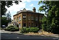
- The higher the marker number, the further away the image location is from the centre of the postcode.
Image Listing (45 Images Found)
Images are licensed for reuse under creativecommons.org/licenses/by-sa/2.0
Image
Details
Distance
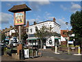
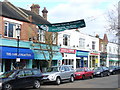
4
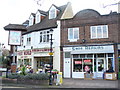
Flowers and Shoes
Village sign, flower shop and shoe repair shop on The Parade, Claygate.
Image: © Colin Smith
Taken: 14 Mar 2009
0.09 miles
5
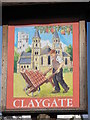
Claygate village sign
At the eastern end of Image
Image: © Mike Quinn
Taken: 1 Oct 2008
0.10 miles
9

Revealed sign on The Parade, Claygate
Every so often building works temporarily reveal the earlier signs for a shop, this is the lower part only as there is still a covering over the name above but still a lucky find.
Image: © David Howard
Taken: 17 Jun 2013
0.12 miles
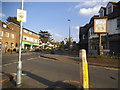
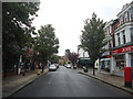
10
Claygate, The Parade
The shopping street at the town centre leads to the railway station.
Image: © Colin Smith
Taken: 14 Mar 2009
0.13 miles