IMAGES TAKEN NEAR TO
Hinchley Close, ESHER, KT10 0BY
Introduction
This page details the photographs taken nearby to Hinchley Close, KT10 0BY by members of the Geograph project.
The Geograph project started in 2005 with the aim of publishing, organising and preserving representative images for every square kilometre of Great Britain, Ireland and the Isle of Man.

There are currently over 7.5m images from over14,400 individuals and you can help contribute to the project by visiting https://www.geograph.org.uk
Image Map
Images are licensed for reuse under creativecommons.org/licenses/by-sa/2.0
Notes
- Clicking on the map will re-center to the selected point.
- The higher the marker number, the further away the image location is from the centre of the postcode.
Image Listing (17 Images Found)
Images are licensed for reuse under creativecommons.org/licenses/by-sa/2.0
Image
Details
Distance
1
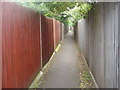
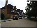
Public footpath between Claygate Avenue and Hinchley Drive
Image: © David Howard
Taken: 16 May 2011
0.15 miles
2
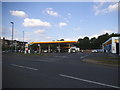
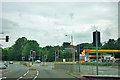
Shell petrol station on Manor Road South
Image: © David Howard
Taken: 7 May 2017
0.16 miles
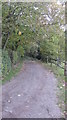
4
Greenways at the junction of Manor Road South
Image: © David Howard
Taken: 14 Jun 2017
0.18 miles
5
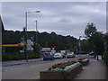
Traffic lights, Hinchley Wood
On the A309 with a right turn to Claygate.
Image: © Robin Webster
Taken: 24 Aug 2012
0.19 miles
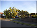
6
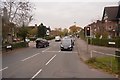
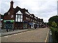
Manor Road, Hinchley Wood
Looking towards junction with the Kingston Bypass
Image: © David Howard
Taken: 14 Jul 2008
0.19 miles
10
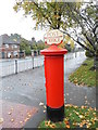
Postbox № KT10 214, Manor Road North
Thanks to Chris Downer for the details. The red lettering has recently been stencilled on the old backing plate of the sign.
Image: © David Howard
Taken: 21 Oct 2012
0.21 miles